
Today:
This morning will start out dry with some cloud cover. As we go into midday, temps should warm rather quickly into the low 40s. Precipitation will gradually fill in from the southwest as low pressure develops to our south and the surface becomes moist, and it may in fact start briefly as a wintry mix around 1 or 2 p.m. given the temperatures. A quick changeover to snow is expected and it will probably begin sticking to the grass and cars in the late afternoon and early evening.
Tonight:
Snow, perhaps moderate at times (rates of 0.5-1 inch per hour), will continue into the overnight and is expected to taper off by dawn. Lows should dip down into the mid 20s so it will have no issues sticking to all surfaces. We’re expecting totals of 3-6 inches when all is said and done, so make sure to enjoy it Terps!
Wednesday:
Widespread cloud cover should persist in advance of our next system (no rest for the weary!), but most of the day is expected to remain dry – plenty of time for snowball fights and snowman building. Highs should only get up into the mid to upper 30s, but leaning on the colder side given all the snow cover.
A wintry mix is likely to begin in the early evening with either snow or sleet as the cold air tries to stick around. However, a quick changeover to plain rain is forecast with the strengthening low pressure feeding warm air into the area. The steady rain should continue well into the night – all the more reason to enjoy the snow during the day before it gets washed away!
Looking ahead:
Things should finally slow down late this week – temps are likely to dip slightly below normal on Friday and early Saturday behind our rainstorm. However, more precipitation is in the forecast for most of the weekend (late Saturday into Sunday), so be sure to bring an umbrella! Taking a very early stab at the forecast for early next week, we could be looking at a more potent cold shot Monday & Tuesday behind that heavy wet weather. Stay tuned!
Discussion:
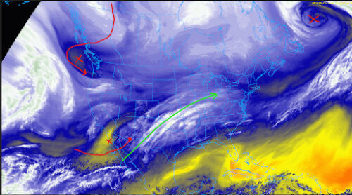
Let’s take a look at water vapor satellite imagery to get an idea of our key players over the next couple of days.
Via https://weather.cod.edu/satrad
All the X’s I’ve marked are basically pieces of energy in the upper troposphere (~18,000 feet), and these mark wherever there’s probably going to be disturbed weather at the surface.
Starting with the top right, the system that brought us some very light rain/icing back on Saturday has become a very strong low pressure system, and the trailing cold front brought us some fairly cold weather yesterday (Monday) and sets the stage for our precipitation to come down in the form of snow.
In the bottom left corner, we have our main system that will bring us snow tonight. The main thing with this feature is that it’s not impressively strong – the appreciable moisture out ahead of it (light blues/whites over the central plains) will be responsible for the first wave of precipitation.
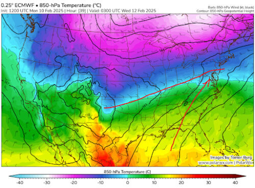
Via www.polarwx.com
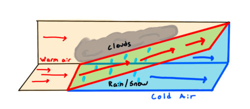
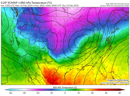
The low pressure system is expected to be quite weak, so why are we still expected to get a good snowstorm? Well, that’s because of a huge temperature difference in the middle of the country. Here, we’re looking at a model forecast a few thousand feet above our heads. Notice how cold it is just to our north and the warmth to our south! All that gulf moisture will ride gently up and over that cold air (since it’s less dense) – that’s how you get snow. To visualize it better:
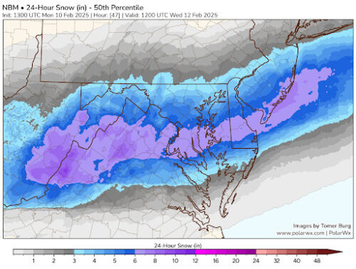
Now let’s talk snow totals. The best chance for at least 6” would be just to our south – below is the median for all the models blended together. The reason I went with a slightly low range (3-6”) for us is to account for temperatures limiting stickage for the first 2-3 hours of precipitation. At such a close range, there’s generally good confidence across the board for the low end amount to verify at the very least.
Via www.polarwx.com
What about the rain following soon after? Since there was no real strong low pressure with tonight’s snow, it doesn’t usher in as much cold either. A much stronger system develops well to our west, and that leftover cold air gets wiped away by strong winds from the south during the day on Wednesday.
Via www.polarwx.com
That’s all for now! Enjoy the snow later today and tonight Terps, and I hope my first article was insightful 🙂
Be sure to stay up to date with our posts throughout the semester!
– Veer T
Featured image via Frances Schoenly