
Good Morning, Terps! Expect more thunderstorms to impact the DMV today, followed by a much-needed break from the high heat on Monday and Tuesday.
Today (Sunday):
A partly-cloudy morning will quickly give way to another afternoon of sweltering heat, with high temperatures near 92 and feels-like temperatures approaching 100 for the third time this week. Severe thunderstorms are likely during the late afternoon into early evening hours.
Monday and Tuesday:
We are finally gifted with slightly cooler weather to start the week. Morning temperatures will linger in the low 60s, while high temperatures will stall around 80 on both Monday and Tuesday. Mostly sunny skies and a light breeze will accompany the cooler temperatures to make for pleasant afternoons. Rain is not expected.
Looking Ahead:
Unfortunately, the cooler weather will not last long, as conditions on Wednesday are expected to return to being hot and humid. Anticipate high temperatures in the mid-to-high 80s with feels-like temperatures approaching the mid-to-high 90s yet again. Thursday will bring more sweltering conditions to the area, with temperatures back into the mid 90s during the afternoon hours. Severe thunderstorms appear possible on Thursday, but details will need to be refined in the coming days.
Today’s Storms:
It is extremely difficult to pinpoint the exact location and timing of summer thunderstorms, and most weather models remain fairly inconsistent regarding the severe weather setup this afternoon. However, using knowledge of local meteorology and pattern recognition from prior events, we can make educated guesses as to where and when storms will fire in the area.
Our thinking is that spotty thunderstorms will be possible throughout the DC region as early as 2:00 in the afternoon, followed by a second line of storms during the late afternoon to early evening hours. It appears as if atmospheric ingredients will be more supportive of stronger storms later in the afternoon, and so the severity of storms today will depend on the timing and placement of the second line.
Any storms that are able to take advantage of the potent environment will certainly be capable of damaging winds up to 75 mph, heavy rainfall, and frequent lightning. However, what separates today from the thunderstorms that impacted the DMV earlier this week is that greater amounts of instability and wind shear will allow for the possibility of stronger and more organized thunderstorms (referred to as supercells). While the overall risk appears to be low, a tornado and large hail cannot be ruled out with these stronger cells.
As of now, the Storm Prediction Center (SPC) has currently outlined a large Slight Risk (Level 2 out of 5), which includes a 30% damaging wind probability and a 2% tornado probability for much of the area. These outlooks are pictured below.
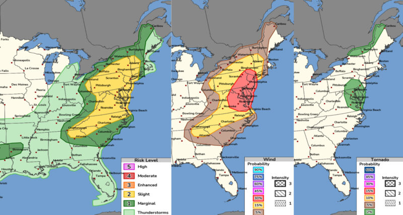
Via www.spc.noaa.gov
We currently anticipate the SPC upgrading the severe weather risk to an Enhanced Risk (Level 3 out of 5) in a future outlook. This would be a wind-driven upgrade, and we would expect the Enhanced Risk to be centered along the I-95 corridor between DC, Baltimore, and surrounding areas. Upgrade or not, please remain weather-aware throughout the afternoon hours nevertheless!
Meteorological Discussion:
The system set to impact the greater DMV area today is the result of several jet stream features and building instability. Pictured below is what the upper-level wind patterns will look like this afternoon, with the two key features circled in yellow.
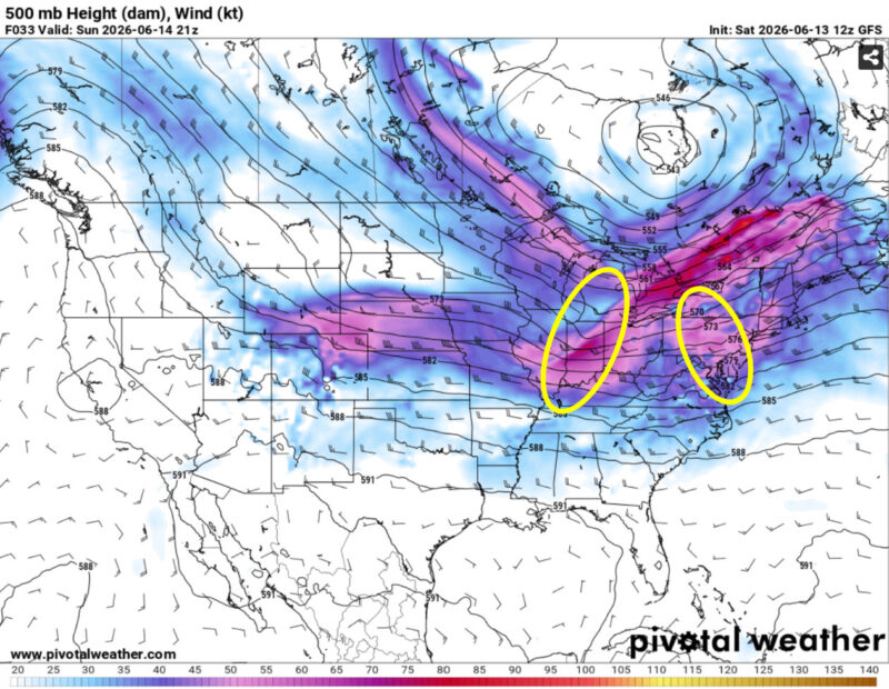
Via www.pivotalweather.com
The leftmost circle highlights a more defined and positively-tilted shortwave trough, which will be located over the Ohio Valley during the beginning hours of the event. This trough will bring with it an associated cold front that will arrive in the DMV during the overnight hours tonight and leave behind slightly cooler temperatures for us to enjoy over the next few days. The rightmost circle highlights a smaller feature that, though harder to spot, will be largely responsible for convective initiation from the Carolinas into the Northeast.
The culmination of several ingredients will lead to a potent atmosphere across the DMV region for this convection to take advantage of. Firstly, southerly flow will allow dewpoints to be exceptionally high (possibly nearing 70 degrees in some areas), meaning that storms will have more than enough moisture to form and may pose localized flooding risks (although unlikely given the current drought conditions).
Instability will also be sufficient in supporting stronger thunderstorms, with surface-based CAPE values (convective available potential energy) nearing 1500-2000 J/kg across eastern portions of the Mid-Atlantic. That, combined with unseasonably strong low-level wind shear, which will build throughout the afternoon and peak around sunset, will allow for vertically-tilted and perhaps supercellular storms that may pose a risk of large hail and a tornado or two.
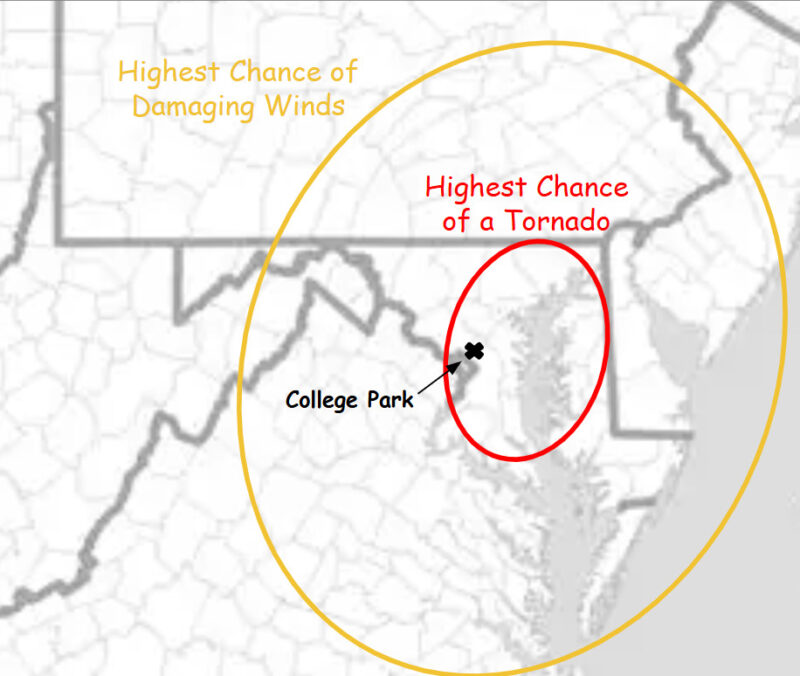
Below is a more localized outlook of where we think damaging winds and perhaps a tornado are most likely to occur across the Mid-Atlantic. These are the zones where, in our opinion, the best atmospheric ingredients and strongest possibility of storm coverage align. The placement of the higher tornado probabilities is largely due to the possibility of favorable storm interactions associated with the Chesapeake Bay breeze, which could lead to stronger areas of spin aloft.
**It is always important to note that, during summer thunderstorm events, a variety of fail modes can result in weaker storms and/or unforeseen results. For example, if the early-afternoon thunderstorms overperform, they may drain the atmosphere of its energy before the more favorable ingredients are able to build across the region. In this case, the second round of storms may not be as strong. Weather, in all of its beauty and power, is sometimes unpredictable.**
That’s all for now, Terps! We hope you enjoyed this detailed breakdown of the severe weather setup today and can take advantage of the cooler temperatures that follow. Reference our local NWS office for mid-day updates, and be sure to stay weather-aware as these storms impact our area. Stay safe, and have a great week!
Author: Donovan Fry
Editor: Anjali Vidyasagar