
Good Morning, Terps! Expect a brief period of warmer temperatures as we near the end of break, followed by a significant winter storm event over the weekend and frigid temperatures that are here to stay.
Today (Thursday):
Expect warm temperatures during the afternoon. Light winds, sunny skies, and a high in the low 50s will make for a pleasant afternoon. Evening temperatures will dip into the high 30s by midnight.
Tomorrow (Friday):
A chillier morning with a low near 28 will give way to slightly warmer temperatures by mid afternoon. A high near 44 will be accompanied by mostly cloudy skies and gusty winds upwards of 10 mph. During the evening to overnight hours, a strong wave of long-lasting cold air will push into the area.
**Winter Storm Update**:
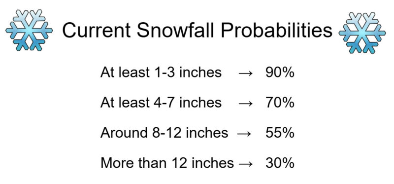
Signs are trending toward a significant winter storm for the DMV. Snow is currently set to begin during the late afternoon to overnight hours on Saturday, and continue into Sunday morning. The precipitation may phase into a wintry mix by Sunday afternoon, before it eventually tapers off early Monday morning. While it is still too early to pinpoint exact snowfall amounts, confidence is growing that this winter storm may be one to remember. Based on current model trends, which are subject to change depending on the amount of ice accumulation we receive, here is our current thinking for local snowfall amounts:
Discussion:
So, why is this happening? It all starts with a wave of energy off the coast of Baja California and an extremely large and powerful trough pulling frigid Canadian air into much of the US. This setup is pictured below, where the wave of energy will move northeastward, clash with the incoming cold air, and spark widespread precipitation everywhere from Texas to the Northeast.
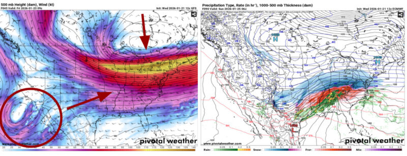
Via www.pivotalweather.com
Originally, models had this system much farther to our south, leaving College Park on the fringe of the heaviest precipitation. However, a few things have changed that may allow for a historic snowfall event in our area. Models have begun to forecast the development of a low-pressure system just off the coast of Virginia, which will help to strengthen the storm in our area and pull slightly warmer air northward. This warmer air would place the snow-ice line much closer to the DMV, resulting in some of the heaviest precipitation falling along the I-95 corridor between DC and Baltimore. Below is what the radar could look like early Sunday morning under these circumstances.
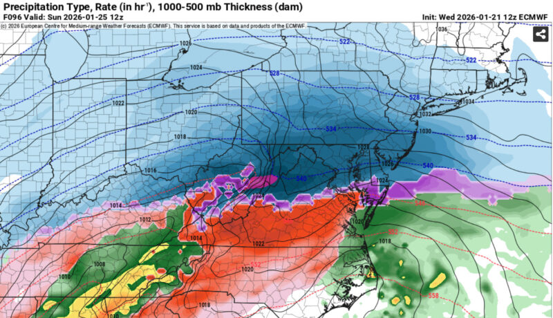
Via www.pivotalweather.com
The reason for our high confidence in significant snowfall totals for College Park is the consistency among models. Although exact amounts vary, the GFS, European, UKMet, and German models all give the DC metro area near or above 12 inches of snow between Saturday and Sunday. Though trends are likely to change over the next few days, this consistency is enough to raise our confidence in a highly-impactful snow storm despite still being 3-4 days out.
Our local National Weather Service office has already issued its highest risk of life-threatening winter weather conditions for this weekend. This is corroborated by the Experimental Winter Storm Outlook (WSO), which places the entire DMV in the highest probability of exceeding winter-storm warning criteria on its Day 4 Outlook, as seen below.
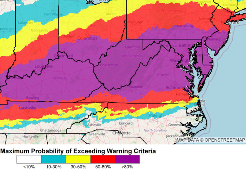
Via www.wpc.ncep.noaa.gov/wwd/wso/index.php?id=LWX
Other Possibilities and Looking Ahead:
It is extremely important to note that forecasts will continue to change over the next few days as more details emerge closer to the event. With the snow-ice line currently placed just south of DC, a further northward shift would lead to a prolonged period of wintry mix on Sunday that could significantly cut down on overall snow totals. Still, this scenario would be just as impactful, as less snow would likely lead to greater ice accumulations. At this point, anything from an icy-wintry mess to a historic snowfall event upwards of 15 inches remains possible.
Although possibilities vary with this winter storm, we can tell you one thing for certain: starting on Saturday, it will be VERY cold for a LONG time. Following the precipitation, temperatures will struggle to reach above freezing for over a week! This will undoubtedly lead to treacherous conditions on campus, where any precipitation that falls will freeze and stay frozen for the foreseeable future. Be careful out there!
That’s all for now, Terps. Stay warm, stay safe, and continue to check our local National Weather Service office for official updates.
Author: Donovan Fry