
Good Morning, Terps! For this short week of class, expect sunny skies today and moderate rain showers tomorrow, particularly in the afternoon.
Today (Monday):
A chilly morning will give way to warmer temperatures during the afternoon. The morning low will dip down into the upper 30s, but mostly sunny skies and light winds will make for a calm and pleasant afternoon with a high near 58.
Tonight:
Winds remain calm as the temperature once again drops into the high 30s by midnight. Cloud cover will gradually increase into the overnight hours.
Tomorrow (Tuesday):
Periods of rain are expected to impact our area during the afternoon hours. Temperatures will increase from about 40 in the morning to the low 50s by the afternoon, while light winds should fluctuate between 5 and 10 mph. Anticipate cloudy skies, with wet and dreary conditions becoming prominent after noon.
Looking Ahead:
On Wednesday, you can look forward to cloudy but warmer temperatures with a midday high in the upper 60s. A stray rain shower will be possible throughout the day. Following Wednesday, clear and dry conditions are expected for Thanksgiving and beyond, but this will be paired with a colder and windier pattern. The current forecast for Thursday indicates partly cloudy skies with a high in the upper 40s, but make sure to tune in for our next discussion later this week for a more detailed Thanksgiving forecast!
Discussion:
Throughout the day on Monday, a high-pressure system will linger over the East Coast, resulting in a stable environment of sinking air not conducive to convective development. However, come Tuesday, a weak shortwave trough will be working its way across the middle of the country, shown below by a dip in the isobars over the southeastern Great Plains.
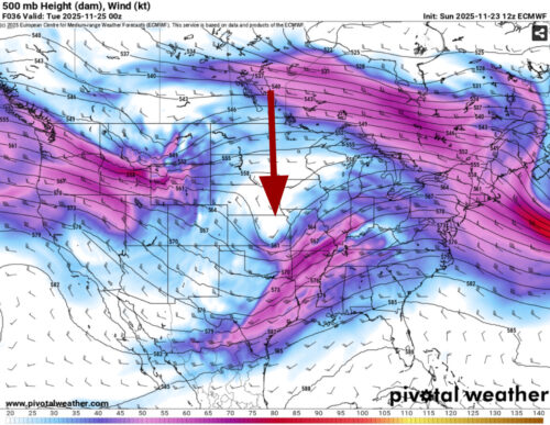
Via www.pivotalweather.com
This trough and its associated low-pressure system, though weak, will bring with it a large area of light to moderate rain showers that will quickly move eastward and impact much of the Northeast. An example of what the radar could look like during the early afternoon hours on Tuesday is pictured below, with most models calling for around a quarter of an inch of rainfall.

Via www.pivotalweather.com
Thankfully, this system quickly exits our area by Wednesday morning, as it is pushed out to sea by a much larger and stronger trough that is set to impact a large portion of the eastern US during the second half of this week. This trough, opposite of the weak shortwave previously discussed, is an extension of the polar jet stream and will help pull much colder and drier air southward into College Park. This is modeled below, where the image on the left displays dry air forcing Tuesday’s moisture offshore, while the image on the right shows the influx of cold Canadian air pushing into the DMV by Thursday morning.
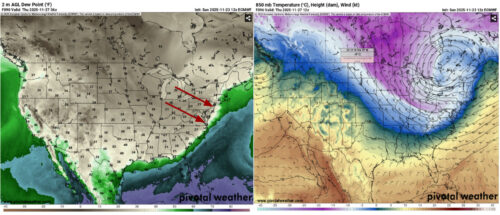
Via www.pivotalweather.com
Thus, you can expect a period of chilly, windy, and dry conditions to end our week.
That’s all for now, Terps. Enjoy your Thanksgiving Break!
Author: Donovan Fry
Editor: Frances Schoenly