
Good Morning, Terps! For this week, expect a stretch of typical fall weather with cool temperatures and partly cloudy skies, followed by some rain later on.
Today (Monday):
A chilly start to the morning will give way to warmer and sunnier conditions later in the day. A morning low of about 40 is expected, with afternoon temperatures approaching 62 degrees. Sunny skies and light winds should make today pleasantly comfortable.
Tonight:
Expect some clouds to move into the area after sunset. Winds remain calm, and temperatures will gradually drop into the upper 40s by midnight.
Tomorrow (Tuesday):
Tuesday will remain fairly consistent with Monday’s weather. Morning temperatures are anticipated to stall in the low 40s, while afternoon temperatures struggle to reach the high 50s. Breezier conditions are expected to impact the area later in the day, so be prepared for mostly cloudy skies and gusty winds possibly near 15 mph to make for a chillier afternoon.
Looking Ahead:
Following a similar day on Wednesday with high temperatures in the upper 50s and low temperatures in the low 40s, a large storm system is set to move into the area Wednesday Night into Thursday. This system has the potential to bring windy and rainy weather to College Park, but is currently expected to clear out just in time for a chilly but calm Halloween. Tune in for our next forecast discussion this Thursday for more details!
Discussion:
Throughout Monday and Tuesday, a shortwave trough with an offshore low-pressure system will bring widespread moisture to much of the Southeast US. Luckily, this small disturbance is expected to stay to our south, keeping College Park dry for the first half of the week. During this time, moderate cloud cover is anticipated to move into the area and should play a small role in limiting radiative cooling overnight and regulating midday heating Tuesday and Wednesday. However, all of this will change on Thursday, as a much larger trough will sweep through the country and eventually make its way into our area (pictured below).
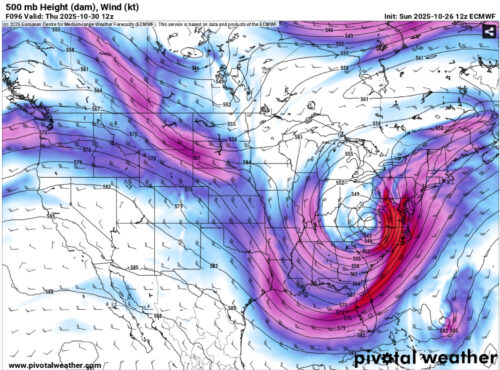
Via https://home.pivotalweather.com/
This trough and its associated low-pressure system will bring two main impacts. First, expect this Thursday to be windier than the first half of the week, as difluence overhead will strengthen a surface low-pressure system and cause increased wind speeds in our area as shown above (purple and red colors represent higher wind speeds). Surface winds between 15 and 20 mph are likely, with higher gusts possible.
Additionally, this storm will allow for moisture to be pulled northward from the Southeast coastline, resulting in large rain bands swirling around the low-pressure system that will push through the Mid-Atlantic. For us in College Park, this means that we should anticipate wet conditions Wednesday night into Thursday, with some models currently forecasting nearly an inch of rain for the greater DMV area. An example of what the radar could look like Thursday morning is pictured below.
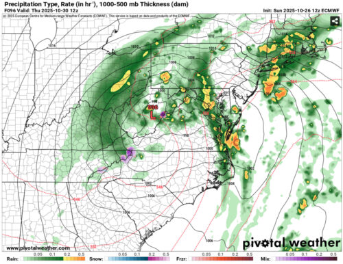
Via https://home.pivotalweather.com/
Thankfully, the system is currently expected to exit our area by Friday, leaving behind similar temperatures and maybe a brief period of breezy weather before calmer (and drier) conditions return just in time for Halloween night. Make sure to come back on Thursday for a more precise Halloween forecast as this storm passes and details become clear.
That’s all for now. Thanks for tuning in, and have a great week!
Author: Donovan Fry
Editor: Frances Schoenly, James Hyde
Featured image via Carlos Sanchez