
Today:
Be prepared for a sunny and chilly day! Morning temperatures begin in the 20s with scattered clouds. By the afternoon, skies will be clear, and temperatures will warm to mid 30s, reaching a daytime high in the upper 30s in the late afternoon. Be prepared for blustery conditions throughout the day, with sustained winds around 15 mph and occasional gusts up to 30 mph.
Tonight:
As the sun sets, expect winds to weaken and temperatures to drop. Evening winds begin around 10 mph at sunset and die down to about 5 mph by midnight. Temperatures will gradually fall from the mid 30s to the mid 20s as we approach midnight. If you’re heading outside, be sure to bundle up!
Saturday:
Saturday looks to be a sunny day with calm winds around 5 mph. Morning temperatures will start in the upper 20s and mid-30s before warming to a daytime high of around 40 degrees in the early afternoon.
Looking Ahead:
Expect calmer weather this weekend! Saturday will remain relatively chilly and sunny, but Sunday will bring slightly warmer conditions with a light breeze. We can expect temperatures in the mid 40s during the day, possibly climbing into the upper 40s or even low 50s. Next week, temperatures are looking much warmer than what we’ve been seeing. Expect sunny skies and daytime temperatures in the 50s for the first few days next week.
Discussion:
When I wrote to you all on Monday, I titled the article “A Windy Start to the Week.” Now, I bring you “A Windy End to the Week.” What a full-circle moment this has been (ha-ha!).
I’ll keep this discussion brief since today’s conditions are similar to those earlier this week, only with slightly weaker winds. I’ll touch briefly on what and why we’ll see some warmer weather next week, as well.
The low-pressure system that brought Wednesday’s flurries has now exited our area and moved into the North Atlantic early this morning. To our west, a strong high pressure zone sits over the midwest. This will be the setup for the high winds we’ll see today!
Similar to what I discussed on Monday, this difference in pressures between the two systems will cause high winds in our area. We can expect a relatively strong northwesterly wind as the two systems interact.
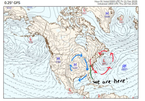
Via www.polarwx.com
The high pressure flowing into our area has been the main culprit for the cold temperatures we’ve seen this week. As we’ve discussed before, a polar vortex typically occurs when a high pressure system sits over Canada and the Northern United States, trapping and dragging frigid Arctic air down into the mid-latitudes (right where we are!). Here’s a snapshot from this morning to give you an idea of what’s happening:
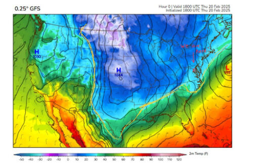
Via www.polarwx.com
You can see that all the cold air sticks to the edges and the area around the high pressure. While this system is weakening, its effects are still noticeable in today’s temperatures.
Although that high pressure system is now much weaker than when it sat over Canada, it will still bring the last of the cold air to our area before moving off the East Coast on Saturday. As it leaves, there won’t be any system remaining to trap any cold air from the north into our area. Thus, our cold spell has ended, and we can expect temperatures to gradually warm into the 40s and 50s heading into next week.
Thanks for sticking with us this week! We hope you all have a good Friday and an even better weekend.
Writer: Frances Schoenly
Editor: Madison Magaha
Featured image by Frances Schoenly