
Today:
Much like yesterday afternoon and evening, we are looking at a sunny and windy day but with higher winds and stronger gusts. Air temperatures stay around the low to mid 30s in the morning, and the daytime high for the air temperature peaks at around 40 degrees in the afternoon. The big feature today is the wind; we are under a wind advisory until 3p.m. Winds are expected to blow in the 20 to 25 mph range, and we could see gusts around 40 mph throughout the day. Be sure to dress warm and windproof. Stay grounded on the way to classes!
Tonight:
The winds are expected to die down slightly as the sun sets but anticipate breezes with wind speeds around 10 mph. Temperatures drop into the mid to lower 20s as we approach midnight.
Tuesday:
Tomorrow isn’t looking terribly different from what we’ll experience today. We’re looking at mostly sunny and cold temperatures throughout the day. Temperatures range from the mid 20s to the lower 30s in the morning, and the temperatures drop into the low to mid 30s in the afternoon. Winds should stay around 10 to 15 mph with the occasional gust; gusts will likely not be as intense as today (Monday), but be prepared for gusts around 20 mph.
Looking Ahead:
The big topic of this week is, of course, the winter storm in the middle of the week. Wednesday is looking to be cold and cloudy; we can all expect temperatures in the 20s with calm breezes. It’s a little too far out to report on the total snow amounts we’ll see here in College Park, but we are still on track to see snow starting in the late afternoon on Wednesday.
Discussion:
The main agenda of the weather discussion today is the wind, cold temperatures, and, of course, the midweek snowstorm we’re all expecting.
The winds today are a result of the strong low-pressure system that rolled through the College Park area yesterday. Wind, in a very basic sense, is caused by differences in air pressure. So, air will tend to flow from higher pressures into lower pressures.
Hopefully, this helps visualize the systems at play throughout today. The low pressure labeled 976 (meaning, 976 millibars for air pressure) is the main player causing our winds today. Any air that is going to flow today will flow towards that low pressure. Some spots have been marked with the wind direction to help you all visualize the wind.
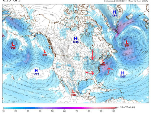
Via polarwx.com
With the passage of this particular system, College Park finds itself nestled behind a cold front, which explains the cold start to our week.
So, the bottom line is to stay warm and be sure to dress appropriately to counter the cold temperatures! In this kind of windy and cold weather, the general rule of thumb is to stay covered if you want to stay warm.
Now, the big question: what about the snow this week? If you’ve been keeping up with the snow amounts, you can probably see that the forecast has been changing quite a bit since this system was announced.
The general consensus is that a blast of Arctic air will blow through the United States, which will make the conditions cold enough to make snow. As of right now, I feel pretty confident we will see some sort of snow in the middle of the week. The big question is how much snow we are going to see and when it will reach our area. The exact amounts will become clearer as the week progresses, but the current models are showing a more southern track for snow (meaning, areas to our south are more likely to see higher amounts of snow).
The short video attached is something called a model trend. This shows how the weather models predict weather events as time goes on. The video starts showing predictions for some of the snow, represented by the blue overlay, for Wednesday evening. These show predictions starting on Saturday morning and ending on Sunday night. It’s a little hard to see, but if you focus on Maryland, you can see the highlighted blue area shift southward as time goes on. The area where the warm, moist air from the south and the cold air from the north is typically where we expect the higher snow amounts. If you look at the dotted red and blue lines, find the point right in between the blue and the red. You can see this pattern as the model moves this section south over time.
Several factors could change how much snow we see and when, of course, but as we mentioned over the weekend, this is just a wait-and-see situation.
(As a student and a forecaster, though, I would definitely recommend studying for any midterms you all have later this week… Don’t procrastinate studying…)
Otherwise, that’s all we have for you today. We will keep you all updated as the week progresses. Stay warm!
– Frances Schoenly
Featured image via Frances Schoenly