
Hurricane Matthew Update
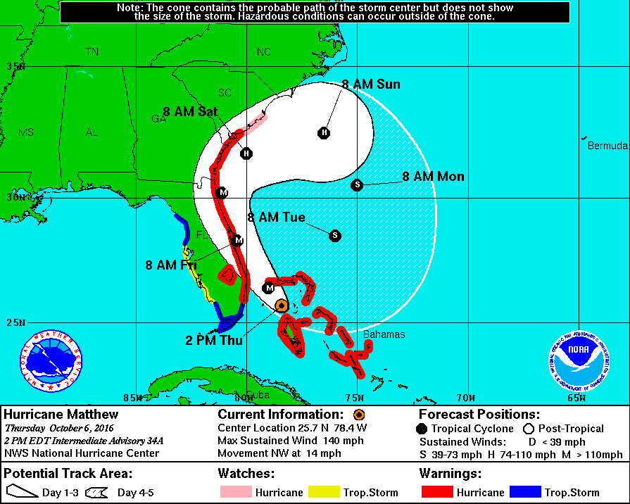
2PM NHC Track for Hurricane Matthew
While Hurricane Matthew delivers high-risk storm impacts for Florida, curiosity on whether the tropical cyclone will pose threats for the Mid-Atlantic continues to rise. Overnight, the storm re-intensified into a category 4 hurricane with a central minimum pressure of 940 mb. Matthew is tracking in a northwestward direction away from the Bahamas and toward the Florida coastline while packing maximum sustained wind speeds of up to 140 mph. The possibility of experiencing major storm impacts in the DC/MD/VA region has reduced due to the current forecast track. In fact, the National Hurricane Center projects the storm to ride up the the coasts of Florida, Georgia and the Carolina’s before making a peculiar loop back into the Atlantic Ocean by Monday/Tuesday.
Locally, the forecast area will relax directly under a ridge of high pressure which will continue to keep the weather pleasantly quiet and dry until Friday evening. Easterly onshore winds will endure on the next few days, allowing an increased moisture flow from the Atlantic Ocean which will enhance scattered cloud coverage. On Saturday, a cold front could initiate some showers, though the timing and amounts remain unknown. An upper level trough will trail a surface cold front into the region and create unsettled conditions on Saturday afternoon. It is very likely to produce cooler below average temperatures for the latter part of the weekend. Next week, high pressure will build and allow dry and seasonable conditions to trend.
Thursday
Low level clouds are refusing to budge, creating a much cooler and cloud covered afternoon than expected. We may see a few breaks in the clouds by late afternoon, but don’t hold out too much hope. Temperatures should be stuck in the mid to upper 60s with a light east wind at 5 mph. Cloud cover is likely to hang on through the overnight period as well, keeping temperatures in the mid to upper 50s.
Friday
Friday’s forecast is a bit up in the air as well. What looked like a warm and partly sunny day has turned grey and uncertain. Low level clouds may be tough to break once again given the persistent easterly flow off the ocean. Should we get some breaks of sunshine, temps will jump to the mid 70s. If not, expect another cool and cloudy day with temps in the mid to upper 60s. Afternoon model guidance is hinting at an increased chance of widespread showers late Friday afternoon into Friday night, in association with low level moisture from Matthew. Should remain partly to mostly cloudy overnight on Friday with temperatures in the 50s.
Saturday-Wednesday
Unfortunately, Saturday is looking to be a washout due to the approaching cold front (Matthew won’t take the blame for this anymore). At 8 a.m. Saturday morning, the TerpWRF model (below) displays precipitation to likely occur in the southwest/northeast locations (DC, Northern VA, Northern Prince Georges County). By 2 p.m., the entire forecast region could experience rain showers that will potentially diminish before 5 p.m. High temperatures will range from the mid 60’s to low 70’s. By Sunday, pleasant weather and cooler temperatures will settle behind the cold front. Maximum temperatures should peak to the mid 60’s while low temperatures drop to the upper 40s. By Wednesday, warmer weather returns and daytime temperatures could increase to seasonable levels.
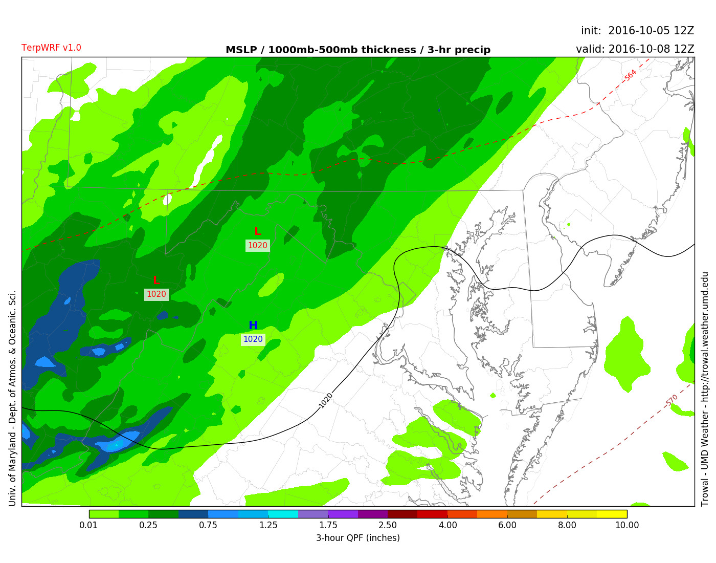
TerpWRF 3-hour QPF displays rain showers for Saturday October 8th at 8 a.m.
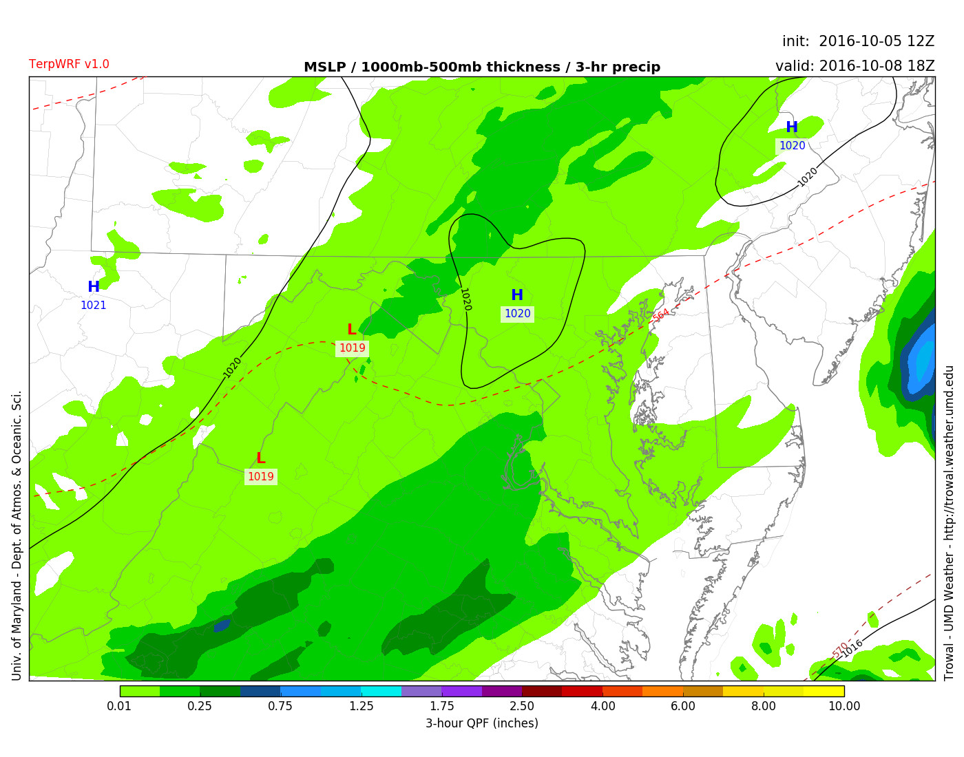
TerpWRF 3-hour QPF displays rain showers for Saturday October 8th at 2 p.m.