
Forecast Overview
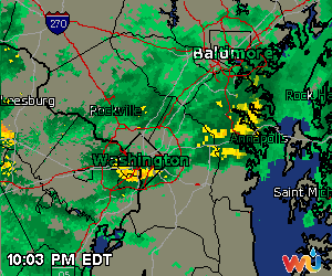
Current Weather Underground Radar displaying light (green) to moderate showers (yellow)
The Delmarva has experienced a washout due the onshore flow of tropical moisture from the Atlantic and an upper level low-pressure system situated over Kansas. The combination of the two separate systems has been producing consistent bands of heavy rain showers and thunderstorms over the DC/Maryland area. Earlier this morning at 7:15 a.m., the National Weather Service storm total rainfall observational reports have exceeded 2.00 inches over the past 36 hours for various locations. Currently, the District (and surrounding locations) received at least an additional 0.79 inches of rain. A Flash Flood Watch will remain in effect for locations in the vicinity of Baltimore and west of the I-81 corridor until 8:00 a.m. on Friday morning. Another batch of precipitation will migrate northward into the region and produce more scattered rain showers on Friday night through Saturday morning. By Sunday, high pressure will begin to build as the upper level low pressure system weakens and diminishes. Seasonably autumn-like temperatures are expected to return by the start of next week.
Thursday Overnight
Currently, overcast skies are accompanied by light-to-moderate scattered rain showers which are moving west-northwestward across the District and Capital Beltway. Overnight rainfall totals will likely increase by at least a tenth of an inch. A marginal risk for severe flash flooding is possible for locations along the Blue Ridge Mountains due to increased instability. Easterly winds as high as 18 to 20 mph will include gusty 25 mph winds. Low temperatures should settle in the low 60’s.
Friday
On Friday morning, widespread rain showers will continue to stick around with 10 to 15 mph winds shifting out of the northeast. Mainly cloudy skies will definitely limit sunshine and produce maximum high temperatures just below 70 degrees. In the afternoon/evening, showers will gradually lighten and spread out across the region.
Saturday
Drizzle/rain showers will linger into the morning and early afternoon hours. Most locations surrounding the Capital Beltway will dry out after 2 p.m. as the precipitation moves northward toward Baltimore. Maximum temperatures are expected to approach the mid-70’s and low temperatures will drop to the low 60’s. The overall chance of rain will range from 40% – 60%.