
Tracking Hermine
Today has been a dreary day in the mid-Atlantic region, thanks to post-tropical cyclone Hermine. The system transitioned into a post-tropical cyclone after experiencing a cooling trend inside the core of the storm. Even though Hermine is now a cold-core system, the dangerous cyclone will continue to produce high energetic wind speeds and tropical storm-like damage along the mid-Atlantic coastal locations. Currently, the eye of the storm is positioned about 280 miles southeast of Washington DC (southeast of Ocean City). It is migrating in an east northeastward direction offshore at 12 mph with intense sustained winds near 70 mph. As Hermine churns off the coast, the storm track will likely experience a significant decrease in speed that will impact the re-development of the storm. The National Hurricane Center (NHC) reports that Hermine may become a stronger and more dangerous cyclone that may potentially reach hurricane status if it stalls out in the Atlantic for ample time. A mid-latitudinal trough, warm sea surface temperatures and an upper level low are three main factors that could impact the re-intensification of the post-tropical cyclone. Under these favorable conditions, Hermine could bring in a few showers across portions of eastern and southern MD throughout the rest of the Labor Day weekend.
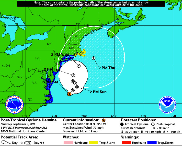
Forecast track for Post-Tropical Cyclone Hermine (CREDIT: National Hurricane Center)
Weekend Forecast
Earlier, a mix of scattered and mostly cloudy conditions limited sunshine across eastern portions of I-95. Limited sunshine and gusty winds maxed out at 30 mph in the District. Since Hermine is currently moving offshore, wind gusts over the DC Metro area will diminish Saturday night.Winds coming out of the north will range between 10 to 15 mph. Overnight temperatures will drop to the low 60s and overcast clouds will blanket the skies. A hazardous weather outlook has been issued for counties near the potomac river, DC and northern VA. As of 6:59 p.m., a tropical storm warning is in effect near the Chesapeake Bay area. Locally, southwest DC near Waterfront and Alexandria, VA will potentially experience moderate tidal flooding. Potential hazardous wind conditions and storm surge are anticipated for southern MD locations near St. Marys County.
Sunday
Sunday will be another dreary day as mostly cloudy skies move into the region. Breezy north winds will range between 5 to 10 mph. Under overcast skies, high temperatures will only reach the upper 70s to low 80s. Low temperatures will settle in the mid to upper 60s and there will be a 20% chance of overnight showers in areas mainly east of I-95.
Monday (Labor Day)
As Hermine creeps back toward the Atlantic coast, northerly wind speeds will increase to 15 to 20 mph and gusts will peak up to 25 mph. Eastern MD (east of the Chesapeake Bay) locations will be trampled with heavy rain showers and potentially heavy wind gusts up to 40mph. Mostly cloudy skies will clear out throughout the day and allow high temperatures to soar to the mid 80s in the District.
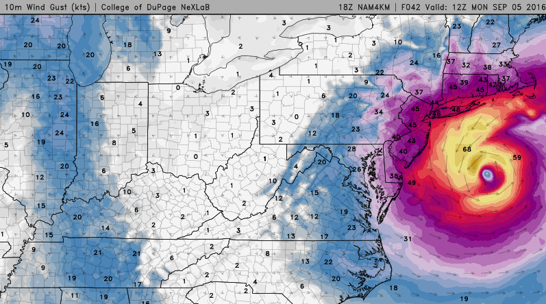
Potential 10m wind gusts on Monday (Labor Day) at 8:00 a.m. (CREDIT: Weather DuPage)