

Sunset at the Monument (Via)
Forecast Overview
High pressure has began to build in from the northeast yesterday, keeping us warm but dry. Over the next 24-36 hours, the ridge of high pressure will begin to breakdown and shifting offshore. On Tuesday, the atmosphere experiences a bit of a traffic jam over our region, with a weak frontal boundary stalling out right between DC and Baltimore. Tropical depression eight will continue to move very little over the next few days, slowly edging closer and closer to the NC coast. Extreme southern portions of the mid-Atlantic may see some high level clouds associated with the system, but that’s about it for impacts around here. By Wednesday, a much more potent cold front sweeps through the area, kicking TD 8 out to see and providing us with a refreshing cool down that should last into the weekend.
Monday Night
We currently have partly cloudy conditions, with some pockets of clouds dotting the area, mainly north of the DC area. A warm and muggy air mass combined with some increased instability will kick off some showers and thunderstorms over the Blue Ridge mountains. Not expecting any precipitation inside the Beltway. Mostly clear overnight with low temps right around 70. Remaining relatively humid.
Tuesday
Another warm and humid day is on tap for Tuesday. Mostly sunny to begin the day, with partly cloudy skies in the afternoon. Areas along the eastern shore could see mostly cloudy skies in the afternoon as TD 8 gets closer to the coast. High temperatures ranging from 88-92 with dew point values in the upper 60s. Pop up showers and thunderstorms should remain restricted to the west of the beltway once again. Mostly clear overnight with low temps ranging from 68-72.
Wednesday and Beyond
All signs point to a strong cold front moving through the region sometime on Wednesday afternoon. Conditions will remain warm and muggy ahead of the front with high temps in the low 90s once again. The frontal passage will very likely result in widespread showers and thunderstorms across the area. The end of the week will feature cooler temperatures and lower humidity values.
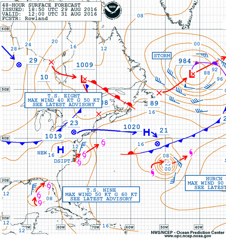
See ya later TD 8. Forecasted surface map for Wednesday morning shows the approaching cold front from the northwest, eventually kicking the storm out to sea. Via OPC
Active Tropics
The late season surge in tropical activity in the Atlantic basin continues, with both TD 8 off North Carolina and TD 9 in the Gulf likely to reach tropical storm status within the next 24 hours. Not too much to worry about with the storm of the NC coast, but the Gulf storm will be something to keep an eye on for sure. As of now, most model guidance moves the storm very little over the next 48 hours before making landfall somewhere along the Florida panhandle as a category 1 or 2 hurricane.