The clear blue skies and pleasant warmth from the past weekend continues today, with highs reaching the low 80s for the DC Metro area. Some might even find today a bit too toasty for their tastes, but all in all, considering the low humidity (dew points staying in the 40s), a fantastic day to bust out the shorts ‘n tees and take that outside lunch break. The snow flurries and chilly winds of just 9 days ago seem like a distant memory now.
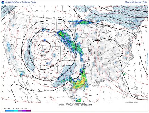
We can credit this benign (and yes, rather boring) local weather to an upper-level atmospheric pattern known as an Omega Block, which is actually quite a common feature for April in the midlatitude Northern Hemisphere. As the Polar Jet lifts North, the upper-level westerly winds, which were rippin’ and roaring above us all winter long, begin to slacken, and the flow patterns become more wavy (or amplified, in Meteorologist-talk), similar to what happens to a rushing mountain stream that transitions to a slowly meandering river after reaching flatter topography. Check out that massive mid-level ridge in the figure below, shaped like the Greek letter Omega (Ω) and stretching from the Great Lakes to the Gulf Coast. Features such as this one block the approach of weather disturbances approaching from the west and force them to turn far to the North, over and around them. Mid-level ridging also supports subsidence (downward-moving air), which inhibits cloud formation.

500 mb geopotential height (black contours), temperature (dashed red contours), and winds for Monday April 18th, taken from NWS Storm Prediction Center (SPC) Mesoanalysis page
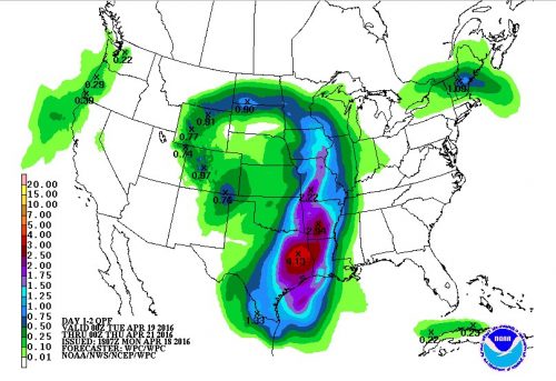
But not everybody wins out in these blocky patterns. Pieces of upper-level spin (vorticity) in the atmosphere often get left behind as the Polar Jet lifts north. Anyone stuck underneath one of these “closed lows” can expect plenty of clouds and below-normal temperatures. Note the closed 500-mb isobars in the figure above, centered over Northwest Colorado/Northeast Utah. Features like this move eastward very slowly, and can take over a week to cross the continental U.S. The southeastern and eastern flanks of these closed lows act like train tracks for upper-level pieces of energy (shortwave troughs) to follow. Since late last week, one shortwave after another has slingshot out of the Four Corners region into the High Plains, spawning surface low pressure systems through a complex interaction between their upper-level spin and northward-streaming moisture out of the Gulf of Mexico. The Rocky Mountain and adjacent High Plains regions had to contend with a significant snowstorm over this past weekend, which brought 8-12 inches of snow to the Denver metro and up to 4 feet to parts of the Front Range. On the warm side of the storm track, southeast Texas has been pummeled with repeat thunderstorms, with the worst of it occurring overnight Sunday into Monday morning. Water rescues continue in parts of the Houston Metro area, where up to 10-20 inches of rain fell overnight! Unfortunately, the rain for southeast Texas is not yet over (see 48-hour forecast precipitation map below). Thanks to the Omega block, areas east of the Mississippi remain dry while the moisture firehose out of the Gulf of Mexico is aimed squarely on the Plains.

48-hour total precipitation (inches) forecast from the NOAA Weather Prediction Center (WPC) for 8 pm EST Monday – 8 pm EST Wednesday
