Spring has officially begun across the DMV, and with the start of new season we can expect our weather to undergo a bit on an identity crisis over the next few weeks. Early spring can be a fickle time of the year for mid latitude regions. Warm and sunny afternoons can quickly turn into cold and blustery evenings. Such is the case for our area this afternoon and beyond.
Short Term
A small but rather robust shortwave continues to quickly to the south east the Great Lakes region and will bring us some precipitation late this afternoon. Ahead of this system, a warm front has draped itself overhead and will likely stall out as the storm rides along the boundary. Surface flow from the southwest has allowed temperatures to quickly jump into the low to mid 60’s. These mild temps will increase instability and has allowed for some gusty winds to mix down from an expanding boundary layer. As such, some rumbles of thunder and heavy pockets of rain with strong wind gusts are not out of the question later this afternoon. Colder air will filter in behind the associated frontal passage overnight with clearing skies and winds relaxing.
Long Term
We will benefit from a breakdown of the strong western ridge later this week as height rises and associated higher pressure will push through our area on Wednesday and Thursday. Thursday in particular looks to be a gem, with temps likely to rise above 70 degrees with mainly clear skies. Unfortunately, this warm up won’t last. A highly volatile and amplified upper level pattern over the US will keep our sensible weather in a period of flux from Friday onward. The first half of this weekend will almost certainly be wet as high pressure moves offshore on Friday and we return to a very moist flow, direct from the Gulf of Mexico. Saturday will be the wetter of the weekend days, while Sunday will be drier but with cooler and gustier conditions behind the cold front passage.
April Forecast
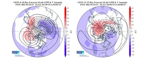
The breakdown of the West Coast ridge (likely the result of a stronger than normal phase 7 of the MJO in mid March) will be temporary. Increased wave activity and vertical propagation into the stratosphere will result in a final stratospheric warming over the polar regions will split the polar vortex into two distinct cells over the next 2/3 weeks as seen below.

500 mb heights and 10 mb heights
The orientation of the upper levels will allow for a rebuilding of the West Coast Ridge, albeit this time in much more negatively tilted fashion. Such an orientation will likely have two main consequences for the mid Atlantic. 1.) Expect frequent and rapid transitions of weather, likely on a 48/72 hour scale. Our position in this type of upper level flow keeps us near the base of a persistent East Coast trough, increasing the likelihood of an active pattern. 2.) The active pattern in combination with the orientation of upper level flow will increase the likelihood of above average moisture over the next few weeks. The jet stream will be in a favorable position to link up with Gulf moisture, creating some extended rain events for us in April.

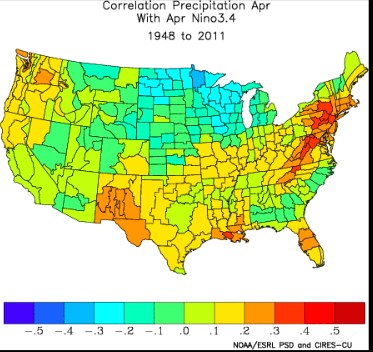
Lastly, recent observations have confirmed the start of a weak El Nino in the central Pacific. Current thinking keeps the El Nino at a weak to moderate phase (> 0.5C) through the fall of 2015. We can already see some effects of this (overactive south Pacific tropics) and we can expect these effects to propagate eastward over time. Historically speaking, the current phase of El Nino has resulted in above average precipitation in April for the mid- Atlantic. (Seen below) The bottom line? Keep those umbrellas close by and don’t put away the winter wear just yet!
