
Today:
The majority of Maryland will be experiencing another mild winter day today. In western Maryland, temperatures start in the low 40s and gradually warm into the upper 40s by the afternoon. Areas in the panhandle of Maryland will stay on the cooler side, with temperatures remaining in the mid-to-upper 30s range throughout the day. The evening will see temperatures drop back into the low 40s, with local temperatures in the panhandle seeing temperatures in the low 30s.
In Central and Southern Maryland, morning temperatures in the high 30s give way to a daytime high in the upper 40s to lower 50s. Come evening, temperatures will decrease into the low-to-mid 40s.
Across the Chesapeake Bay, morning temperatures in the Eastern Shore will start off in the upper 30s before quickly heating to a daytime high in the low 50s by the afternoon. Evening temperatures gradually slope into the mid-50s throughout the region.
Throughout the state, winds will be in the 5 to 10 mph range over the course of the day. Expect overall cloudy conditions across the state. Certain locations in western Maryland, especially the panhandle area, have the chance to see some light rain throughout the day, along with possible non-accumulating flurries in mountainous regions.
Tonight:
A cold front will cross the region, bringing with it colder air into Maryland overnight. Western Maryland will see temperatures in the upper 20s, with localized areas, especially those in the panhandle region, seeing nighttime temperatures in the teens.
Overnight temperatures in central Maryland will be in the low-to-mid 30s, with localized areas in southern Maryland in the low 40s.
The Eastern Shore will see evening temperatures linger in the low 40s before dropping into the low 30s.
Overnight into the early hours of Thursday morning, winds will pick up into the 15 to 20 mph range. Localized wind gusts surpassing 20 mph can be expected in areas bordering the Chesapeake Bay.
Thursday:
With the arrival of the colder air brings a chilly morning for much of the state of Maryland, so be sure to stay warm if you will be outside tomorrow!
Western Maryland morning temperatures will start in the low 20s. Localized areas will see temperatures in the single digits! Afternoon temperatures will be in the mid-to-high 20s before dropping into the low 20s by the evening, with localized temperatures in the teens.
In central and southern Maryland, morning temperatures vary in the 20s range throughout the region, with temperatures in the upper 20s in southern Maryland. Afternoon temperatures eventually reach a high in the upper 20s. Localized areas in southern Maryland can expect a high in the low 30s. Evening temperatures return to the 20s range. Areas close to the Pennsylvania border may see temperatures slightly below 20 degrees.
Eastern Shore morning temperatures start in the mid-to-upper 20s. A high around 30 degrees is expected throughout the region in the afternoon. Following this, evening temperatures cool into the mid-20s.
In most of the state, winds throughout will remain in the 15 to 20 mph range. Keep in mind that windy conditions can lead to temperatures feeling colder than the stated ranges! Early in the morning, southern Maryland and the Eastern Shore may experience rainy conditions, which will move out of the area before the morning commute. Besides this, the state will remain partly cloudy throughout the day.
Looking Ahead:
The majority of Maryland will see mild temperatures briefly return on Saturday, with the warmest temperatures in southern Maryland and on the Eastern Shore (upper 40s) and the coldest temperatures in the panhandle region (high 20s). The passage of another cold front will bring colder temperatures and windier conditions back into the area on Sunday.
Via www.pivotalweather.com
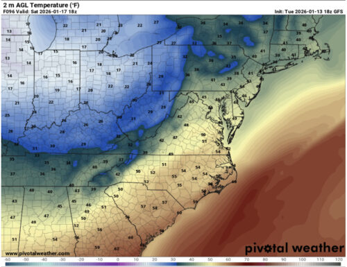
Here is a map of the surface temperatures Saturday afternoon, before the arrival of the weekend cold front. The green and yellow coloring is indicative of temperatures in the mid-to-upper 40s, while the blue temperatures at the tip of the panhandle region indicate temperatures in the high 20s.
Via www.pivotalweather.com
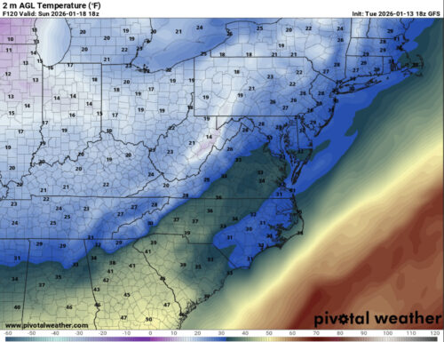
Here is the surface temperature map for Sunday afternoon, after the passage of the cold front. Temperatures in the 20s are expected throughout the state, with the exception of some temperatures in the low 30s in the Eastern Shore. It looks like we will be feeling those winter temperatures once again this weekend!
That’s all for today. We hope everyone has been having a great winter break!
- Writer: Anjali Vidyasagar
Featured Image via Anjali Vidyasagar