
Today:
Expect a sunny and beautiful day! Temperatures will start off in the low 30s around 7 a.m. before climbing into the upper 40s to low 50s by the afternoon, eventually reaching an evening high in the low 60s around 6 p.m. Winds will be breezy once again, ranging from 5 to 10 mph, with gusts up to 20 mph by late afternoon.
Tonight:
As the evening sets in, temperatures will slip into the mid 40s. Winds will stay light around 5 mph, and partly cloudy skies will give the night a calm, cool feel.
Friday:
Temperatures will start in the mid 40s to low 50s, climbing to an afternoon high in the upper 60s. Light showers are expected later in the day, so don’t forget a raincoat! Winds will be light at 4 to 6 mph, with gusts up to 10 mph.
Looking Ahead:
Looking ahead to the early weekend, we’re in for a warm stretch; quite the change from what we’ve seen lately! Saturday will be partly cloudy with temperatures climbing to near 80, making it a perfect day to get outside and soak up some sun, Terps! Showers return by Sunday afternoon, with temps in the upper 60s to mid 70s. Winds will stay light both days, around 5 to 10 mph, so be sure to make the most of that Saturday sunshine!
Looking into early next week, showers will stick around, with temperatures holding in the mid 70s before a noticeable cool down into the upper 50s by Tuesday.
Discussion:
We can thank an advancing warm front for those pesky Friday showers!
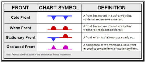
Figure 11-4. Fronts. Adapted from Aviation Weather Handbook (FAA-H-8083-28), Federal Aviation Administration, 2024.
Here is a nice graphic from the FAA’s Aviation Weather Handbook that shows the different kinds of fronts, and what they represent.
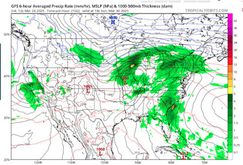
Below is a screenshot from the GFS model valid around 1 p.m. Friday, showing bands of precipitation moving through our region. These showers are being driven by warm air advection associated with the warm front, which is progressing northward as warmer air replaces the cooler air already in place.
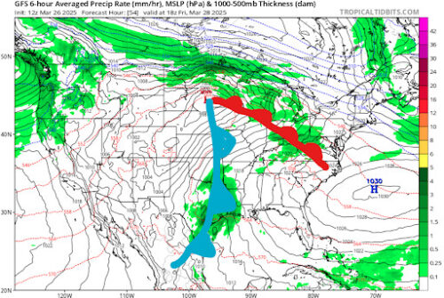
Via tropicaltidbits.com
As warmer air pushes over the cooler air already in place, it rises gradually, a process that leads to lift, causing the air to cool and condense, forming clouds and light precipitation. Since warm fronts have a shallow slope, the rising motion is more gentle, which is why we tend to see stratiform, layered clouds- like nimbostratus, rather than the towering cumulonimbus clouds common with cold fronts. This also explains why precipitation with warm fronts is usually lighter and less intense. The atmosphere ahead of a warm front is also generally more stable, further limiting the vertical development of clouds and reducing the chance of strong thunderstorms.
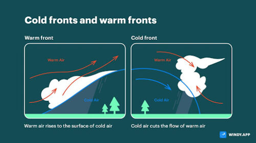
Figure. Cold and warm weather fronts. Adapted from Milovanova, V., Windy.app (n.d.).
Here is a nice figure that shows you the different types of clouds and associated weather to expect with different advancing fronts.
Included below is a screenshot from the ECMWF model, also valid around 1 p.m. Friday. Here, the red-shaded areas indicate warm air advection, while the blue areas show cold air advection. WAA occurs when warmer air is transported into a region by the wind, typically from the south or southwest. This advection supports the lifting process and helps fuel cloud and precipitation development ahead of the front.
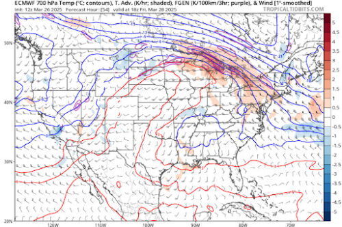
Via tropicaltidbits.com
Below is a screenshot from around 1 p.m. on Monday. You can see the low-pressure system that’s been tracking across the US will be the culprit behind that rain early next week. So stay dry and don’t forget your umbrella!
Via tropicaltidbits.com
Thanks for reading and have a great day, Terps!
Written by: Madison Magaha
Edited by: Frances Schoenly
Featured image via Madison Magaha