
Today:
We’re looking at similar conditions to yesterday’s lovely weather, only slightly chillier. Morning temperatures start in the mid 40s before warming up to a daytime high in the mid 60s in the afternoon. Expect a slight 5 – 10 mph breeze and dry conditions. Overall, we can look forward to mostly sunny and pleasant conditions throughout the day.
Tonight:
Expect a chilly and cloudy night. Temperatures fall as the sun sets and will center around the mid to lower 40s by the late night. Alongside the drop in temperatures, cloud cover will build up from sunset into the early morning. A sustained slight breeze lingers around 5 mph throughout the night.
Thursday:
Overnight cloud cover continues into Thursday morning, making way for partly cloudy conditions throughout most of our Thursday. Expect morning temperatures in the upper 40s and low 50s to warm up to the upper 60s in the afternoon. Temperatures could creep into the lower 70s. Winds are expected to remain around the 5 mph mark.
Looking Ahead:
The week will finish out relatively uneventfully; Friday is expected to be similar to the conditions we’ll see today. On Friday, we can expect partly sunny skies and temperatures in the upper 50s and low 60s. However, the weekend is looking to be much warmer and wetter than the week. As we enter the weekend, we’re looking at temperatures in the 70s with rainy conditions. The majority of the warm temperatures and rain is expected to fall on Sunday.
Discussion:
Hopefully everyone enjoyed the pleasant weather yesterday. After taking a quick look at the UMD micronet, it seems yesterday’s high temperature around campus settled within the lower 70s range in the late/afternoon and evening. Winds were also fairly light as well; different parts of campus were a little windier than others (likely due to the positioning/geography of the various stations around campus), but wind speeds stayed within the 5-10 mph range, for the most part. Pretty neat! Yesterday was textbook sit-on-McKeldin-mall weather.
Moving to today, we’ll see a slight dip in the temperatures today compared to yesterday, but the difference in temperatures won’t be anything too dramatic. The main culprit will be a backdoor cold front (a south-moving cold front) that provides us with some shifting winds and a few clouds before stalling over our region. It will also blow some cool air down to where we are, which will lower our temperatures slightly.
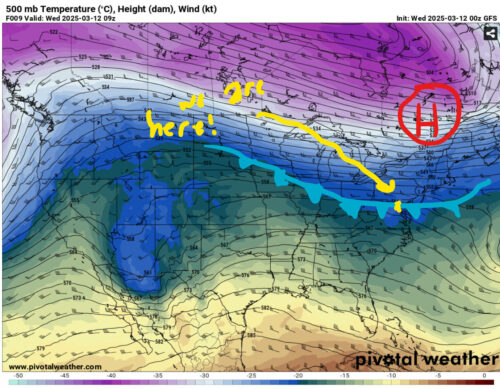
Via www.pivotalweather.com
We’ll be looking at relatively dry conditions throughout most of the day today due to the cold front shown here, as well.
Regarding some of the conditions we’ll see throughout the rest of the week, we can expect to have some pretty uneventful weather. The only major change we would experience is a change in humidity and cloud cover in the later week due to high amounts of gulf moisture segwaying up the East Coast.
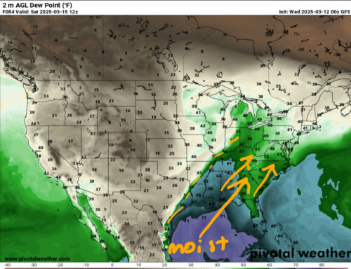
Via www.pivotalweather.com
The map above is showing Dew Point. Dew point is the temperature air needs to be cooled at in order to produce things like rain and clouds (in our case, it’s looking like clouds). It’s a useful tool when forecasting water content in the atmosphere!
Interesting conditions are brewing for the weekend as a strong low pressure zone makes its way up through Canada. For our area of concern, this will help move plenty of Gulf moisture into our area. As this low pressure system moves up the eastern portion of Canada, it will help some showers to form in our area on Sunday. Following this low pressure system is a cold front, which will provide us with most of the thermodynamics necessary to create some rain towards the end of the weekend.

Via www.pivotalweather.com, WPC
We hope you enjoy another nice day outside! Stay tuned for more forecasts.
Written by: Frances Schoenly
Edited by: Anjali Vidyasagar
Featured image via Anjali Vidyasagar