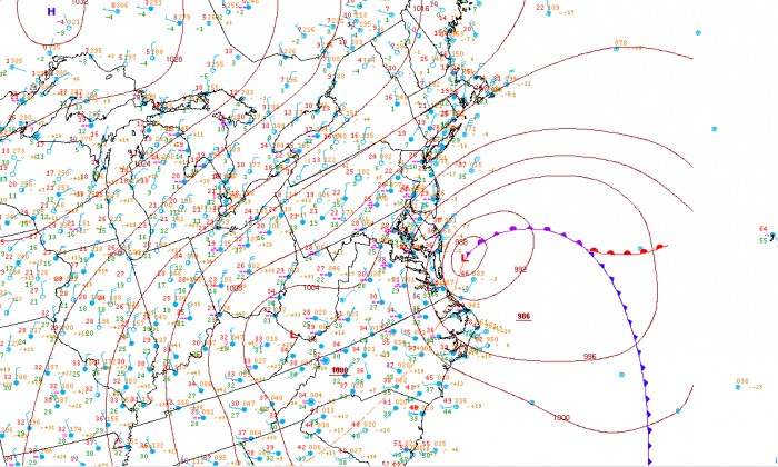
The news has been spreading fast. The Washington D.C. area is in store for a potentially historic winter storm this upcoming weekend. But what makes this storm so anomalous? Before we discuss the specifics, lets take a look at the most recent large winter storm in our area. When people think of major snow storms that blanketed the the Washington D.C and Maryland region, the first that comes to mind for most is the February 5-6, 2010 storm now famously known as Snowmageddon. Other historic snow storms for our area include the January 1996 Blizzard and the February 1983, with each storm dropping anywhere from 20 to 30 inches for much of the I-95 corridor. While there are many differences between each of those storms, they all feature a maturing area of low pressure exiting the North Carolina/Virginia coast moving north and staying close to the Delmarva coast. The deepening low pressure moves north the cyclone occludes (reaches a mature stage) off the coast of the Delmarva Peninsula. Take a look at the surface map from Ferburary 6th 2010, during the peak of Snowmageddon:

Strengthening low pressure sits just offshore of DC/Maryland
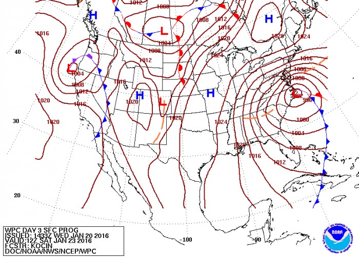
With some ingredients that goes into a major snow storm for the Washington D.C area discussed we can begin to take a look at the Friday snowstorm. Lets first take a look at the surface map forecast from the Weather Prediction Center (WPC) for 12z Saturday. Look familiar?

Forecast surface analysis for 12z Saturday by the Weather Prediction Center
In this forecast surface map the area of low pressure is very similar to what was seen in Snowmageddon and the other previous major snowstorms. The cyclone moves north off the North Carolina coast and is already in the process of occlusion by the time it reaches the same latitude of DC. Another key ingredient for snow in the Mid-Atlantic region is an area of high pressure to our north, which allows the precipitation to stay as snow instead of changing over to rain and cutting down the snowfall totals. In the map above there is high pressure system to our north which not only helps keep this from becoming a rainstorm but also increases the pressure gradient over the Mid-Atlantic region. This tightening gradient will allow winds to greatly increase winds and lead to white out conditions and possibly blizzard conditions.
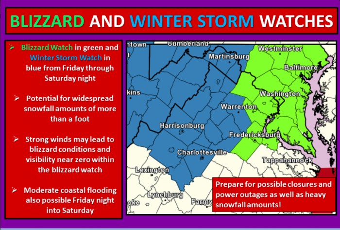
The weather models are in good agreement that winds will be high enough for blizzard conditions, which are 35 mph sustained winds and visibility less than a quarter of a mile lasting for three or more hours. This almost unanimous agreement between the global models (GFS, Euro, and CMC) has lead to the first ever Blizzard Watches for the Central Maryland area, including Washington D.C and Baltimore, issued by the National Weather Service (NWS) at Sterling, Virginia.
Details Of Storm:
The 12z models today continue to support the idea of heavy snowfall for much of Maryland. There are some minor discrepancies between each of the global models, however, each model and their ensembles are in relatively good agreement with snowfall totals and timing of the snow.
- Start Time: The trend today on the models has been pushing back the arrival time of the snow. The first snow flakes should arrive into the area after 1 PM for College Park. The snow will begin south and move north with areas near Baltimore and north not starting until after 3 PM. Conditions will gradually go down hill during the late afternoon hours, which means any preparations for the storm should be done by early Friday.
- Friday Night into Saturday Morning: Winds will begin to increase with sustained winds over 35 mph during the over night hours and snowfall intensity increasing as well. Blizzard conditions are possibly throughout the night into the morning, with near zero mile visibility at times. With the 700mb low moving just to the south of our during the early morning hours of Saturday and the associated high upward vertical velocities over our area intense snowfall rates of 1 inch an hour or more could occur.
- Saturday afternoon into Sunday: Heavy snow will continue for rest of Saturday afternoon with high winds persisting in our area. Snowfall will begin to decrease Saturday night as the storm begins to move out to sea, with just flurries by early Sunday morning. Winds will still be high and blowing snow is possible through Sunday, however, the high winds will finally slow by Sunday afternoon.

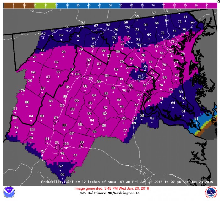
Probability remains high that the entire DC area will see at least 12 inches of snow
Besides the heavy snowfall potential, this storm could bring other hazards to the Mid-Atlantic region. With the area of low pressure near the Delmarva coast, high winds coming out of the east will help pile up the water at the coast. This could lead to a very serious coast flooding situation, possibly rivaling many of the great coast flood events to impact the Mid-Atlantic.

NWS Sterling office issued their first ever Blizzard Watch in anticipation of the storm
Uncertainties:
While the model consensus is relatively high, the storm is still 3 days out and there is potential for issues to occur.
- The biggest uncertainty in the forecast is how for west the rain snow line moves. As the area of low pressure matures of the Delmarva Peninsula winds out of the east will advect an elevated warm air layer around the 850mb level. This warm layer will cause mixing issues and could change areas over from snow to rain. The models currently have the rain snow line east of the I-95 corridor. However, given the strong easterly winds a shift of only 25 miles could cause the I-95 corridor to switch over to sleet on Saturday.
- Snowfall Totals: The models have been consistent over the last 2 days with the snowfall totals over the region. The GFS has been predicting very large snowfall totals, as well as the European model. Snowfall prediction is one of the hardest variables for weather models to predict and they should be taken with a grain of salt. However, with that said there is an increasing chance of very heavy snow for the Central Maryland region. Central Maryland has the highest chance of seeing the best dynamics of the storm and given the large amount of moisture available, large snowfall totals are expected. The NWS has over 20 to 22 inches of snow for the DC metro region, which seems reasonable given the factors at play. Regardless of the final snow total travel will be near impossible starting Friday Night into Saturday and preparations should be made of a possible crippling snowstorm.
Stick with the UMD Weather Center for continuing updates before and during the storm.
