Today:
It is the last of the beautiful days here in College Park, as it looks like fall has finally arrived and it is here today. Expect sun filled skies in the morning with clouds increasing as the day progresses as the cloud extents of Hurricane Nicole (currently impacting Florida and the Southeastern U.S.) slowly make their way into our area. It should be another beautiful, unseasonably warm day for us, with temperatures in the mid 40s to start the morning and reaching a high of 70 by the afternoon. It is the perfect day for hammocking on the mall, and be sure to take advantage of it, as it will likely be the last nice day with temperatures like this for some time.
Tonight:
Clouds slowly build as the night progresses. Expect temperatures to remain mild, with the cloud cover keeping the temperature stable in the mid to high 50s throughout the night. The remnants of Nicole slowly make their way into our area, as we can expect to see rain beginning in the early morning hours of Friday as the first bands pass over us, giving us an early look at the day ahead.
Tomorrow (Friday):
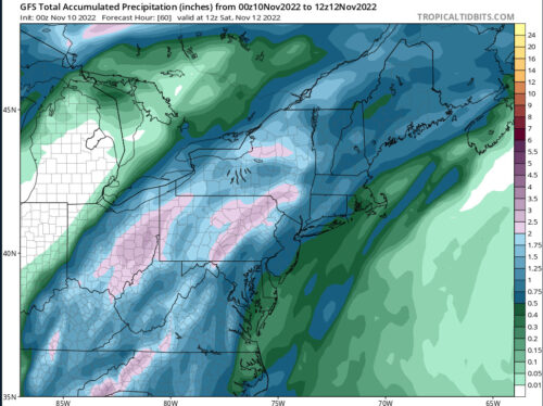
Friday will be a wet one, with rain throughout the day and warm temperatures continuing, with a high in the low 70s. Prepare to get wet walking to class, as rainfall is expected to begin in the early morning and continue into Friday night with the possibility for scattered thunderstorms. With forecasted rainfall amounts of half an inch or more, be prepared for some typical UMD sidewalk flooding.
A Look Ahead:
As this storm moves out Friday night, seasonally cold temperatures return to our area. The weekend looks sunny but colder, with Saturday remaining mild in the mid 60s and the cold hitting Sunday, with highs forecasted in the upper 40s. Looks like fall has finally come to College Park.

GFS forecasted precipitation through Saturday (retrieved from: tropicaltidbits.com)
Featured image via Pixelbay.com
