
Most of the interesting weather this week will come from an upper level trough (and its corresponding surface low) expected to pass through our area on Wednesday. As of yet, we can’t rule out the possibility of thunderstorms in our near future, as well as the possibility of a wind advisory associated with the cold front that may kick off these thunderstorms.
Today:
Before Wednesday, we can expect beautiful springtime conditions! Today, the high will be 74 degrees F, and the sky will be mostly clear of clouds. With our high temperature hovering about 5 degrees above normal highs for this time of year and mostly sunny conditions, today would be a great day to get your outdoor activities in before the weather turns nasty later this week…
Tonight:
The low temperature tonight, compared with previous nights over this past week, will be a relatively warm 55 F. Accompanying these relatively warm temperatures, we can expect increasing cloud cover overnight. Some model output (i.e., GFS) suggests quite a substantial amount of cloud cover by tomorrow morning.
Tomorrow (Wednesday):
Tomorrow, we can expect cooler temperatures than today. The high temperature will be around 67 F, however, this is dependent upon the timing of a cold front that will pass through our area midday. If the cold front passes a little later in the day than it is currently expected (around noon or 1 p.m.), we can expect a larger high temperature as well as a heightened chance for some thunderstorms (due to increased instability near the surface). As the cold front passes, the wind will switch from south to west and will increase considerably in speed to around 15 mph, with gusts as high as 37 mph. If no thunderstorms occur, we can still expect somewhere around one-tenth to one-quarter of an inch of rain tomorrow, mostly in the late morning and afternoon, although rain could persist into the evening.
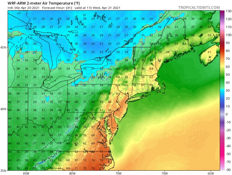
Two-meter temperature valid at 1 p.m. Wednesday (4/21/2021) from the WRF-ARW model. Image courtesy of Tropical Tidbits. We can see the cold front that is about to pass through our area in this image, represented by the stark contrast between green/blue and the yellow/orange over our area. The timing of this front will determine our high temperature tomorrow, as well as our chances of seeing a thunderstorm (I hope we do!)
A Look Ahead:
After the rain on Wednesday, temperatures will remain colder through the weekend. The high temperatures for the rest of the week will remain below their normal values for this time of year, particularly on Thursday. In addition, we may see some breezy conditions on Thursday. Be on the look out for a wind advisory in the next few days, and stay tuned for the next article for updates!
Featured Image courtesy of Clairy Reiher.