
UPDATE 5:30PM: NWS Baltimore/DC just issued a severe thunderstorm watch for the area until 10pm.
Throughout early Monday morning we have seen lots of low-level clouds and fog but conditions continue to rapidly change. A cold front located just south of the Maryland/DC area slowly pushed north through the region this afternoon. This frontal passage caused a spike in temperature and humidity, with temps reaching the upper 70s to low 80s with dew points in the 60s.
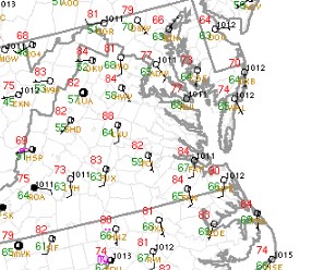
Afternoon temps region wide have jumped into the upper 70s and 80s
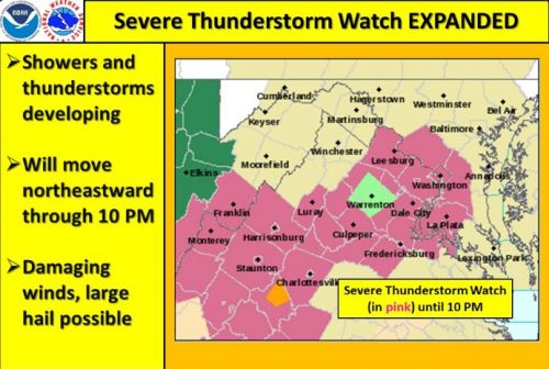
Severe thunderstorm watch expanded
So, great news for those who are looking forward to a more summer-like feel. But, the high humidity and temperature conditions will favor a higher mean layer CAPE (an index used to gauge potential for thunderstorms and severe weather). This will create a more unstable atmosphere which may increase the potential for evening thunderstorms. The potential for strong storms will be slightly enhanced due to a stalled cold front lingering around the Baltimore region combined with decent wind shear (read more about wind shear). With clear skies and sunshine this afternoon, the cold air mass that was stuck near the surface this morning will have the chance to erode away quickly enough to help generate the instability needed for thunderstorms and severe weather.
Expect to see the first few drops of rain sometime after 6pm with the possibility of thunderstorms until 10pm. The biggest severity factor of these storms will be the potential for damaging wind gusts in southern Virginia and a slight possibility of hail in parts of the storm with stronger updrafts.
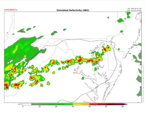
Terp WRF shows a line of thunderstorms over DC at 8pm tonight
Please don’t forget to stay away from windows and be aware of trees from damaging wind gusts!