
Today was just another manic Monday, and boy do I wish it was still Sunday because rainy days are easier to appreciate when you can stay inside. Today the weather was dreary and drizzly, casting a sleepy vibe all over campus. Even though it was humid, high temperatures were only in the mid 70s, making it a fairly comfortable day outside. The weather for the rest of the week is going to get a little more interesting as hurricane Florence approaches the East Coast, so keep an eye on the weather forecasts as we get closer.
Tonight:
Late this afternoon and this evening, a warm front will be moving through the College Park area bringing scattered showers and thunderstorms. Skies will remain overcast, and the temperature is only expected to drop to near 70 degrees. A light breeze around 5 mph will be coming from the South. Some patchy fog is expected late tonight and into tomorrow morning.
Tomorrow (Tuesday):
Tomorrow will be similar to today, but warmer. High temperatures will reach up into the low-to-mid 80s, and the humidity will stick around. Fog will remain in the area in the early morning. All throughout the day there is a chance for scattered showers, and there is a chance for thunderstorms in the afternoon. Skies will be mostly cloudy. Winds will shift to be coming from the Northwest. The chance for showers persists through the evening, and low temperatures will be near 70 degrees.
A Look Ahead: Florence
Everybody wants to know about hurricane Florence and what it will mean for different regions along the East coast. As of today, it is still early to tell exactly what will happen and what effects will be seen where. We do know that Florence will most likely make landfall between South Carolina and Virginia, but this does not mean that other regions, like ours, will be unaffected. As noted in the figure below, hazardous conditions CAN occur outside the cone that depicts the potential path of the hurricane.
On Thursday our region will begin to experience increased wind from Florence but to what magnitude is still unsure. Even if we do not get any severe impacts, you should be thinking about your hurricane plan just in case. Flooding is also possible in our area due to the fact that it will be raining all week ahead of the storm. Extra precipitation from Florence (even if just a little bit of rain) falling on already saturated ground could cause flooding in certain areas. Forecasts will be updated and become more specific throughout the week, so make sure you routinely check back in with UMD Weather and the National Hurricane Center for updates.
As of today (Monday), Larry Hogan has declared a state of emergency for the state of Maryland.
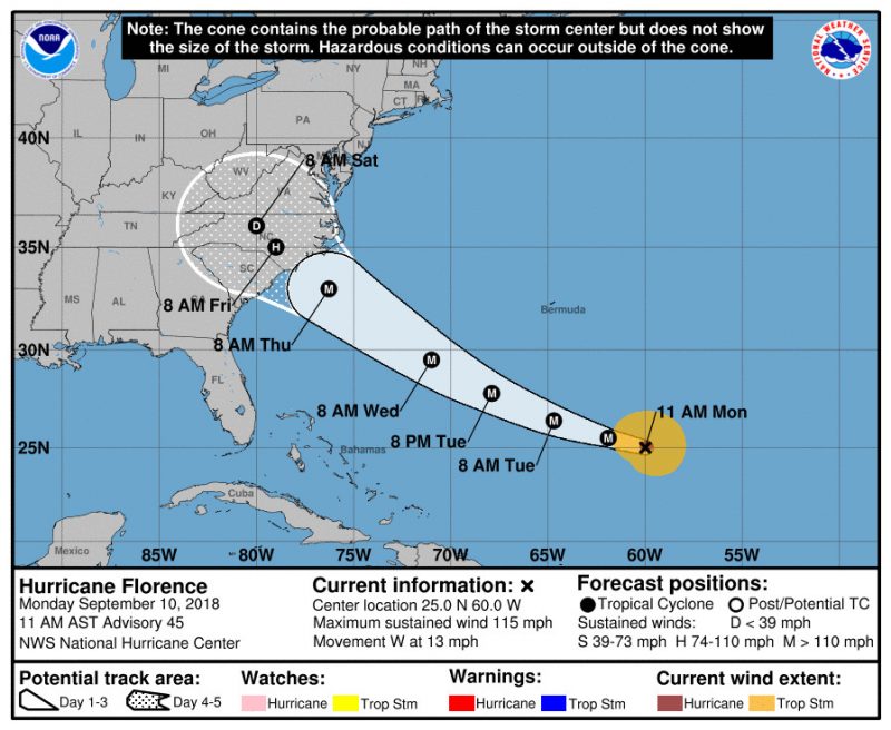
The figure above shows the potential path of hurricane Florence over time (via the National Hurricane Center).