So far this spring, Maryland temperatures have tended to stay below average for this time of year, which made winter seem like it was lasting forever. We even got snow over SPRING break! Fortunately, in College Park this week we will see high temperatures in the 70s and 80s. These temperatures have me yearning for summer nights and s’mores.
Through Tonight:
Overnight temperatures will drop down to the lower 40s, and skies will become partly cloudy as they gradually clear overnight. These cool temperatures will be accompanied by a light wind from the Southwest at about 5 mph. It will be quite a brisk evening, so be aware of that is you are venturing out across campus tonight.
Tomorrow (Thursday):
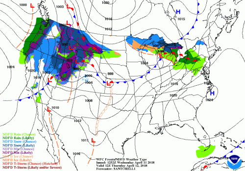
FINALLY. WARM. WEATHER. Thank the heavens above because the high temperature for tomorrow is in the mid 70s. A high pressure system to our Southeast will bring warm air into the mid-Atlantic region from the South. Skies will be mostly clear with a very small chance of a shower in the early morning as the warm front passes over our region, but the rain will mostly stay North of Maryland. The winds will pick up throughout the day, with steady wind from the Southwest at 10-20 mph. Tomorrow night temperatures will drop to the mid 50s with Southwest winds at 10-15 mph. The warm temperatures, dry air and windy conditions have prompted the NWS to issue a Fire Weather Watch for Thursday so please avoid any outside burning.

This forecast image shows the surface weather for tomorrow (Thursday). The high pressure off to the Southeast and the warm front just to our North are bringing warm temperatures to Maryland. (Via NOAA National Weather Service)
A Look Ahead:
Friday and Saturday are going to be nice as well, which is a great way to start off the weekend. Friday skies will be partly cloudy with high temperatures near 80! Winds will stay consistently from the Southwest at 10-15 mph. The weather Saturday will be almost exactly like the weather on Friday with highs even warmer in the lower 80s.
Featured Image via the author
