
It’s time to put the shorts and flip flops back in the closet for a bit, because you’re going to need your rain coat and rain boots these next few days. According to the National Weather Service, Tuesday and Wednesday’s high temperatures of 78 and 82 degrees each broke the record for daily maximum temperature at Reagan National Airport. However, temperatures quickly dropped last night and brought us back to reality. We still have to make it through this last stretch of winter, but these chilling rains will turn to spring showers before we know it.
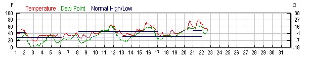
Monthly weather history for Reagan National Airport (via Weather Underground).
Through Tonight:
The rain has held out so far, but it will settle in before long. We will see winds from the northeast at 5 to 10 mph with an 80% chance of rain with patches of drizzle this evening and through the night. Tonight’s low temperature will be a much more seasonable at 37 degrees.
Tomorrow (Friday):
We are looking at a drizzly Friday morning up until 1pm when the rain will let up, but the clouds will stick around. Luckily, new accumulation will be in the ballpark of 0.1-0.25 inches, so hopefully we won’t see too many puddles! Temperatures will get up to about 50 degrees, and winds will be light and variable.

Our whole area will get light rain tomorrow (via WPC/NOAA).
Featured photo courtesy of Pixabay