
The last bits of summer are still holding on as we wrap up another day with above average temperatures. We can expect similar for tomorrow as the ridge over the eastern half of the United States continues to strengthen.
Through Tonight:
Not much change tonight! Skies will stay clear for the rest of the evening through the night with temperatures reaching down into the mid 60s. Winds are still being influenced by Hurricane Jose, coming out of the NW around 5-7 mph, but will become calm overnight.
Tomorrow:
Happy last day of summer! It will definitely not feel like summer is leaving us though. Temperatures will start in the mid to upper 60s and will quickly heat up to the mid 80s as the day progresses. Skies will stay clear with maybe a few cumulus clouds as winds will be light and variable out of the north.
Tropics Update:
It has been an extremely eventful hurricane season with Hurricane Harvey and Hurricane Irma causing mass destruction in the tropics and the southern United States. If you thought it was over and there could not possibly be another hurricane as strong as either of them, you were wrong.
Hurricane Maria, who was a puny Category 1 hurricane on Monday morning, rapidly intensified to a Category 5 monster in 18 hours. The central pressure of the storm, which is an indicator of the strength of a storm, dropped from 977 mb to 924 mb right before making landfall on the island of Dominica. The sustained winds were at 160 mph as it ripped through the entire island, causing catastrophic destruction.
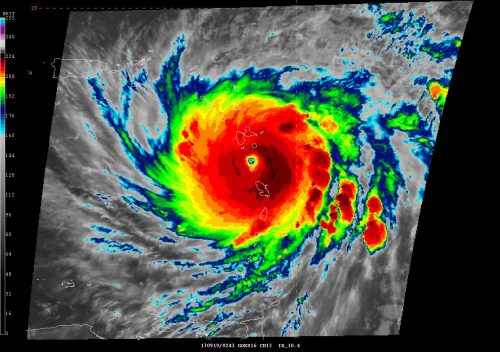
Powerful Category 5 Maria encompassing the island of Dominica vis GOES 16 (non-operational) IR imagery. (via. NOAA)
Maria was not finished there though. Weakened by the 5000′ mountains on the island, Maria began to restrengthen once she made it to open water and began heading straight towards the Virgin Islands and Puerto Rico. Maria’s central minimum pressure reached 909 mb during this intensification period, which was stronger than Hurricane Irma’s lowest minimum central pressure of 914 mb.
Maria made landfall in Puerto Rico at 6:35 this morning just shy of a Category 5 with sustained winds at 155 mph and a minimum central pressure of 917 mb. Following Hurricane Irma, millions were without power in Puerto Rico and infrastructure was weakened. Maria was the last thing they needed.
Damage reports are now flooding in from Puerto Rico. According to a report given by CNN, the entire island is 100% without power. Flash floods and mudslides are expected to devastate infrastructure that was not already affected by the hurricane force winds.
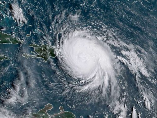
Satellite image of Hurricane Maria over Puerto Rico. (via NOAA)
Hurricane Maria took a beating herself after leaving Puerto Rico. Currently, the central minimum pressure is at 961 mb with sustained winds at 115 mph, making Maria a Category 3 hurricane. Hurricane warnings are in effect for the Dominican Republic and the southern Bahama islands. It is uncertain for sure if Hurricane Maria will have any effects on the continental United States, but it will be something to keep an eye on over the next week.
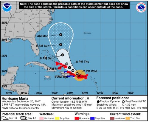
The official 5 day forecast for Hurricane Maria. (via NHC)
Just a reminder, don’t believe everything you see on social media! For all of your official hurricane forecasts, go to the National Hurricane Center’s website.