
The cool temperatures and wind chills in the 20s throughout the week called for hats, scarves, and gloves for your daily commute to class. Today there was some relief, with calmer winds, temperatures reaching 50 degrees, and sunshine peeking through by the afternoon. However, this weekend will be a turn-around and you’ll be sure to catch some spring fever!
Through tonight: Expect wintry temperatures throughout your evening. Temperature will quickly drop to lower-40s when the sun goes down and mid-30s after midnight. Fortunately the wind or precipitation won’t ruin your night! There will be calm winds at 2-5 mph under partly cloudy skies.
Tomorrow (Saturday): Put away your puffy coat and get outside! The maximum temperatures will reach mid- to upper-60s with winds ranging between 3-8 mph from the south. Though fairly cloudy at times, the warmth and light winds will provide some much-needed relief from this week’s bitterness. Chance of showers increases for Saturday evening, most likely after midnight if anything at all.
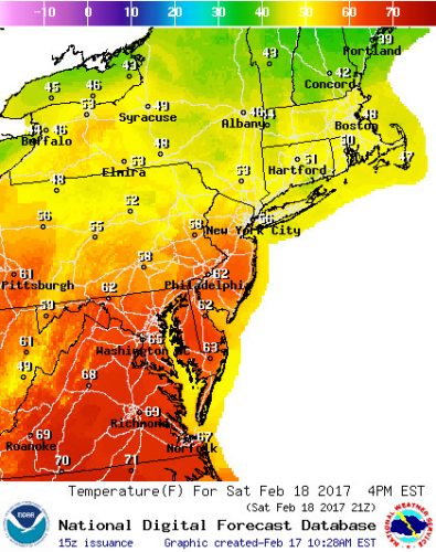
Forecasted temperatures for 4pm on Saturday for US Northeast region, showing 65 degrees for Washington, DC area (via National Weather Service)
Sunday: If you end up enjoying your Saturday, you’re in for a treat Sunday. The maximum temperatures should be in the upper-60s, with a chance of hitting 70 degrees because of the mostly sunny skies. The winds will pick up a little ( ranging from 8-11 mph from the northwest). Overall it should be another beautiful day to end the weekend.
A look ahead: The Climate Prediction Center puts Maryland at a 70% probability of being above-normal temperature for the next 6-10 days. This is good news for those who are eager for spring and bad news for anyone who wanted a February snowstorm.
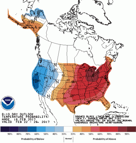
6-10 day outlook for temperature, showing Maryland at 70% probability of experiencing above-normal temperatures (via Climate Prediction Center)