This Winter So Far
So far this winter has not been something to remember. Snow has been hard to come by and ice has been the only real travel issue. A cold shot in early January was the only real reminder that winter had actually started. With true cold temperatures and ideal storm tracks lacking; Baltimore has only measured 0.7 inches of snow so far. DC has only recorded 0.4 inches, while Dulles has another low total of 0.7 inches (as of January 29th). Each of these rank in the top 10 lowest snow totals up to this point on record.
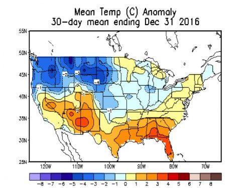
December temperatures were slightly above average in the Mid-Atlantic, while the cold air was trapped in the northwestern states. (Via CPC)
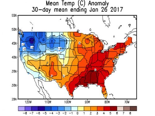
The Eastern United States temperatures were well above normal for January. (Via CPC)
What February Normally Brings
If you like snow and cold weather but have been greatly disappointed this winter…there is still some hope. Historically, February has produced the snowiest months on record for both DC and Baltimore. For DC alone, this month has produced 6 out of the 10 snowiest 3 day periods on record. Including the historic February of 2010. However, one thing to remember is that as we get closer to the end of the month the sun angle and hours of daylight can hurt snow chances.
So What Will Happen This February?
We head into the first half of next month in a fairly favorable pattern for cold and snow. You can determine this by looking at the latest European and GFS ensembles.
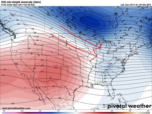
European Ensembles for 2/6 show a nice northwesterly flow towards the East coast due to a ridge in the western United States. This results in colder temperatures in the East, warmer in the West. (Via Pivotal weather)
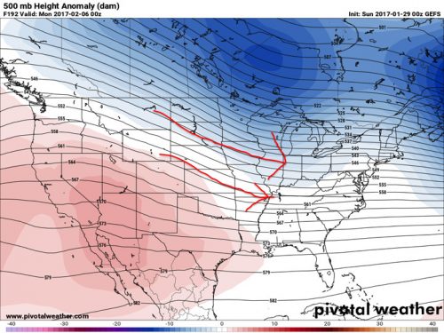
The GFS ensembles are a little less amped as the European, but still shows the same idea. (Via Pivotal Weather)
If these upper air maps verify and prove to be correct, the East coast would experience temperatures around average to slightly below average. Therefore, any moisture or storm systems moving up along the east coast would result in some sort of wintry mix or snow. The Climate Prediction Center shows the general idea of below/average temps in their weekly outlooks below.
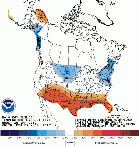
CPC shows below average temperatures for the first week of February. (Via CPC)
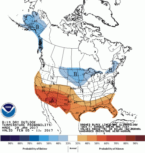
CPC shows temperatures around average for the second week of February. (Via CPC)
Beyond two weeks it is helpful to look at some teleconnections to get a sense of what may occur in the long range. One that is useful to study is the Arctic Oscillation (AO). When the AO goes into a negative phase it means there tends to be a high pressure in the polar region, which in turn can displace the colder air southward towards North America. Here is a look at the GFS ensembles AO outlook.

As you can see the AO has been positive back to December 1st. However; most projections take the AO down to neutral or negative, which would result in colder air spilling to North America. (Via CPC)
Another teleconnection is the North Atlantic Oscillation (NAO). When the NAO is negative there is a blocking high-pressure system over Greenland. This result is a more “wavy” jet stream. This can lead to more blockbuster snowstorms that head up the east coast. This does not mean that a snowstorm cannot occur if the NAO isn’t negative, but most big snowstorms occur when it’s in the negative phase.

As you can see all ensemble members keep the NAO positive, which makes it not the most impressive pattern for a big snowstorm. There does appear to be a downward turn come middle of February however. (Via CPC)
Finally, when looking into the long range it’s best to look at the stratosphere. According to UMD undergraduate student Troy Arcomano, “we start looking at the stratosphere which is ‘easier’ for the global weather models to predict. The newest GFS and ensembles have the current consolidated polar vortex breaking up with one piece going over Siberia and the other over eastern Canada.” This would then produce colder than average temperatures across the east coast.
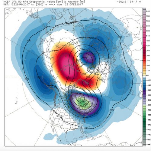
The GFS is showing a polar vortex split. (Via WxBell)
Conclusion
After looking over all the data it appears that February will feature average to slightly below average temperatures across the College Park area. The likelihood of a blizzard like that of January 2016 or February 2010 appears low, but is not completely out of the question if the NAO can get into its’ negative phase. I expect many chances of snow as the month goes on. Also, I am confident that February will be the snowiest month of this winter by far.
What Several Undergraduate Students Predict
| Name | Amount (inches) |
| Alex Ortiz | 5.4 |
| Chris O’Brien | 2.5 |
| Aisha Murphy | 5.0 |
| Troy Arcomano | 14.0 |
| Keenan Eure | 16.0 |
| Kevin Dougherty | 13.0 |
| Cody Snell | 12.8 |
Featured image courtesy of Pixabay
