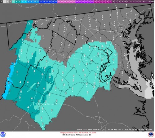
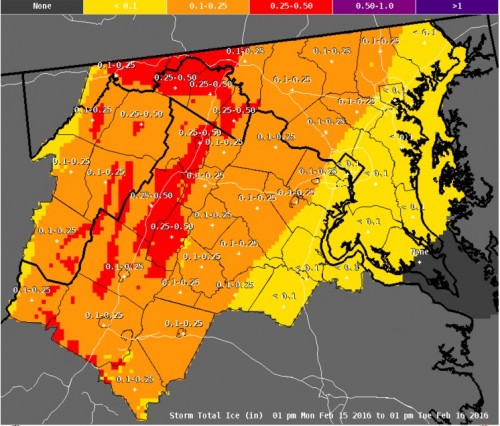
Last night, the entire region experienced the coldest weather of 2016 so far, with minimum temperatures this morning ranging from the single digits to low teens. However, the cold blast is only temporary and the Arctic High pressure responsible for the cold weather is moving off shore as we speak. One more cold afternoon for Valentines Day before a complicated storm system begins to affect the area later on this evening. Nothing easy about this one. Prepare for a mixed precipitation special as we will see snow, sleet, rain and possibly some freezing rain before all is said and done. The details:
Overview:
A strong low pressure system will begin to take shape over Mississippi this afternoon. Ahead of the storm center, a potent warm front will push toward the DC area, spreading precipitation from west to east late tonight. Eventually, the combination of the passing warm front and the storm system passing well to the West of us will flood the region with warm air, first in the upper levels and then at the surface, changing all precipitation to rain. This much we know. However, the cold air from this weekend won’t budge without a fight. As such, the onset of the precipitation is likely to start as snow for everyone, followed by a changeover to sleet and mixed precipitation as the upper levels of the atmosphere warm to above 32 degrees and then ultimately to rain for all. Let’s talk about the known knowns and known unknowns. (Thanks Rumsfeld!)
Timing:
Snow should hold off in the DC/Baltimore area until at least 3AM tonight. By daybreak tomorrow, moderate snowfall should be occurring region wide. Changeover to sleet will happen gradually from south to north on Monday afternoon. Timing of changeover highly uncertain! The warm front will be battling with entrenched cold air at the surface all day. Current thinking is that the DC area should expect a transition to sleet/freezing rain late Monday afternoon, with Baltimore changing over not long after.
Impacts:
With such a mixed bag of precipitation, expect significant impacts across both commutes on Monday and on Tuesday morning’s commute as well. The big wild card will be how much snow falls before the changeover occurs. Additionally, the precipitation changeover won’t be a clean one. Sleet AND freezing rain are anticipated across the entire region on Monday night. Even a small amount of freezing rain could make travel treacheries on untreated surfaces.
Precipitation Amounts:
Low confidence in snowfall/sleet/freezing rain forecast totals. Take a look at the NWS Sterling office’s current thinking. This situation is very fluid and these forecasted totals will likely have to be updated in real time as the storm develops and the small scale features (warm front, mixing, etc) can be more accurately worked out.
Keep checking the UMD Weather Facebook and Twitter pages for more updates tonight and check back here tomorrow for a more detailed update!


