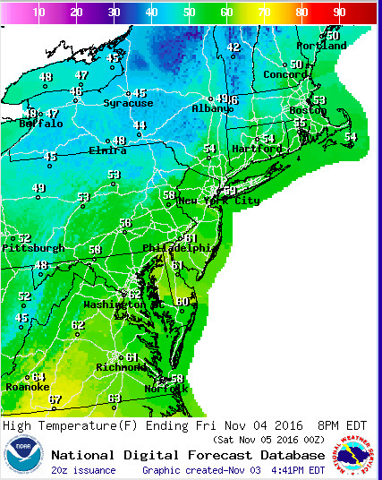
Another day, another record broken. Temperatures around the DMV spiked to the low 80s this afternoon, aided by strong southwest winds ahead of an approaching cold front. Clouds and showers moved in a few hours earlier than anticipated, limiting sunshine and keeping things pretty grey overall. We will hold onto the summer like warmth for a few more hours before temperatures take a nosedive once the cold front moves through tonight.
It was one of the all-time warmest November days in DC today: https://t.co/79C67YxRDL
— Capital Weather Gang (@capitalweather) November 3, 2016
Through Tonight: As of 5pm, the cold front is currently draped from west to east across Pennsylvania, moving somewhat quickly to the south. Ahead of the front, winds have picked up and surprisingly have already shifted to a more northwest direction, likely do to a weak surface boundary developing out ahead of the main cold front. Mostly cloudy skies become partly cloudy overnight with temperatures dropping into the low 50’s. Winds from the northwest will gradually calm down by daybreak.
Friday: Don’t expect any 80 degree temperatures tomorrow. We are under the influence of a new and cooler airmass behind the departing frontal system. Mostly sunny skies and much more seasonable with afternoon temperatures ranging from 60-64 degrees. Northwest winds will pick up once again, gusting to 15+mph at times.

Friday’s high temperatures will be 20 degrees cooler than today.
