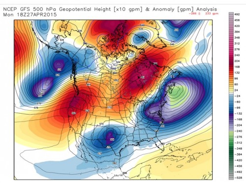
For the second to last weather discussion of the semester, we started out by looking at current surface and upper level air maps for the United States. First we took a look at the 300 and 500 mb level maps and discussed how the ridge that has been sitting over the Western United States for much of the winter and spring continues. This ridge over the West led to a trough over the Eastern half of the United States and has been the cause of the below average temperatures for our area during the second half of April.

GFS Analysis showing the ridge over the West. Provided by WxBell
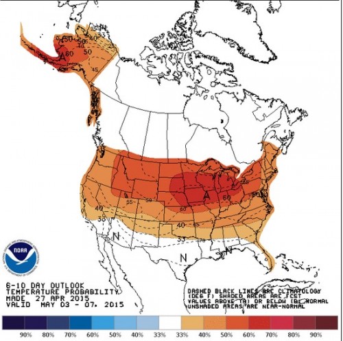
We then looked at today’s 6z GFS and 0z ECMWF models to see how the weather for much of the United States could play out over the next 5 days. Both models agree that an area of low pressure could form off the east coast, but disagree if our area would see rain. The GFS has rain during the day of Friday, while the ECMWF has little to no rain. However, both models agree that this weekend could be a nice one with seasonable temperatures and clear skies. Looking at the Climate Prediction Center’s (CPC) long range forecast, slightly above average temperatures and dry conditions will be the general pattern as a ridge starts to build over the Eastern US.

6-10 Day Temperature Forecast From The CPC
Late April and May is the peak time of the year for tornadoes, but surprisingly the GFS and ECMWF suggest that there will be little severe weather for the US over the next 5 days. So instead of tracking the lack of severe weather we looked back at two past severe weather outbreaks who’s anniversaries were yesterday and today. Yesterday was the 4th anniversary of the April 27, 2011 Super Outbreak. On that day over 200 tornadoes tore paths of destruction through the South East and Mid-Atlantic areas. Tragically, that day 324 people lost their lives, making it the deadliest single tornado day since 1925. The Washington Post made an excellent interactive post on the survivor’s prospective of the Tuscaloosa tornado, which can be found here http://www.washingtonpost.com/posttv/afterthestorm/index.html#/dear-futu…. We discussed some aspects that caused this outbreak, including the high helicity and CAPE that occurred on that day. Also today is the 13th anniversary of the La Plata tornado, which was an F4 tornado that killed 4 people. The tornado is the strongest tornado in Maryland history.
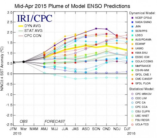
El Nino has been the talk lately in the meteorological community, so we decided to take a look at the current sea surface temperatures. All of the Nino zones (1-4) had above average temperatures and looking below the surface we observed that there is an area of very above average temperatures around 100 meters below the Nino zone 3.4. Finally, we looked at both statistical and dynamical models so see if the El Nino conditions could persist into the Summer and Fall months. Most of the models show that a slight to possibly moderate El Nino will continue into the Summer months.

ENSO Models from CPC
