We hope you are having a great weekend! If you have not heard, there is a Nor’easter impacting the Mid-Atlantic and Northeast starting tomorrow. While models are still showing different trends, we are here to bring you up to speed with the possible scenarios of this event.
Snow Totals:
While total accumulations could change, current estimates for the College Park area are around 2 to 4 inches, with the slight possibility of more than 5 inches. This snow will be heavy and wet, as opposed to the light, fluffy snow we saw from the January winter storm before it transitioned into sleet. Fluffy, light snow occurs when temperatures are well below freezing. Heavy, wet snow typically occurs when temperatures are right around freezing, which is what we will be seeing tomorrow into Monday.
The Set-up:
There is a blast of arctic air once again making its way into our area thanks to a dip in the jet stream, providing favorable temperatures for snowfall in the Mid-Atlantic and Northeast Sunday afternoon. As mentioned above, models are showing a classic Nor’easter set-up, which is a name for a strong extratropical cyclone (a large low-pressure system that develops outside of the tropics) that makes its way up the East Coast, bringing heavy snow and potential blizzard conditions to the Northeast region. There is currently a developing low-pressure system off the coast of the Southeastern U.S., which is expected to make its way up north tomorrow afternoon. This storm will be a wind and snow event, unlike the January winter storm which brought sleet/ice along with snow. Tightly packed pressure contours, as seen below, indicate strong winds. The current low central pressure is in the 970 mb range. If this were a hurricane, it would be classified as a Category 2 hurricane! An inverted trough alongside the low pressure system may lead to localized narrow bands of heavy snowfall.
Model Trends:
Let’s take a look at what the American (GFS), European (ECMWF), and Canadian (GDPS) models are saying about the Nor’easter so far. Each model varies its positioning of the low-pressure center and the changeover of rain to snow.
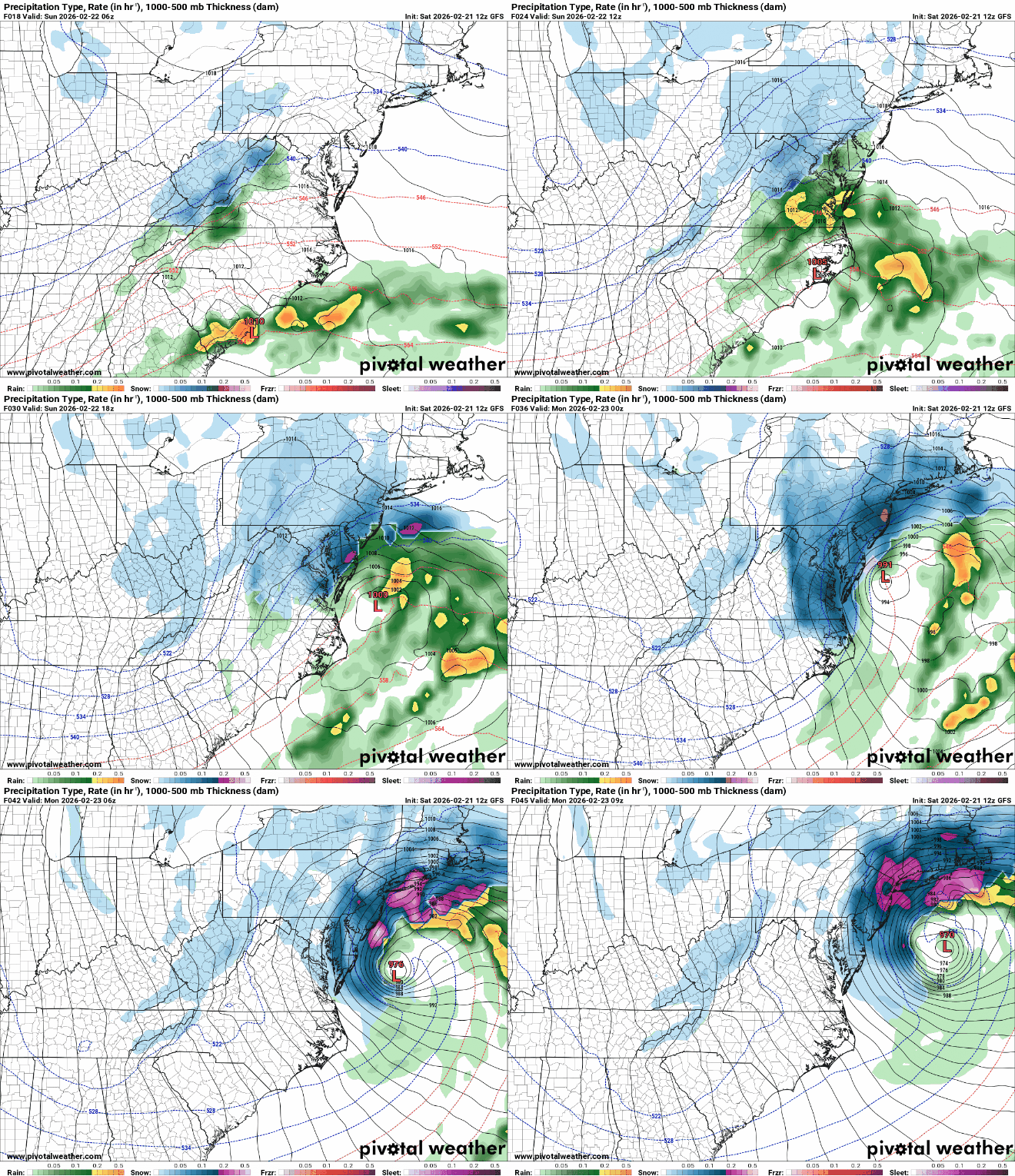
The GFS features more intense snow for our area, due to the positioning of the low-pressure system closer to the coastline. The upper-level trough in our area, according to the GFS, has a stronger negative tilt, leading to more intense snowfall for a larger amount of the area. Also, the snow starts earlier in the afternoon with this model.

Via www.pivotalweather.com
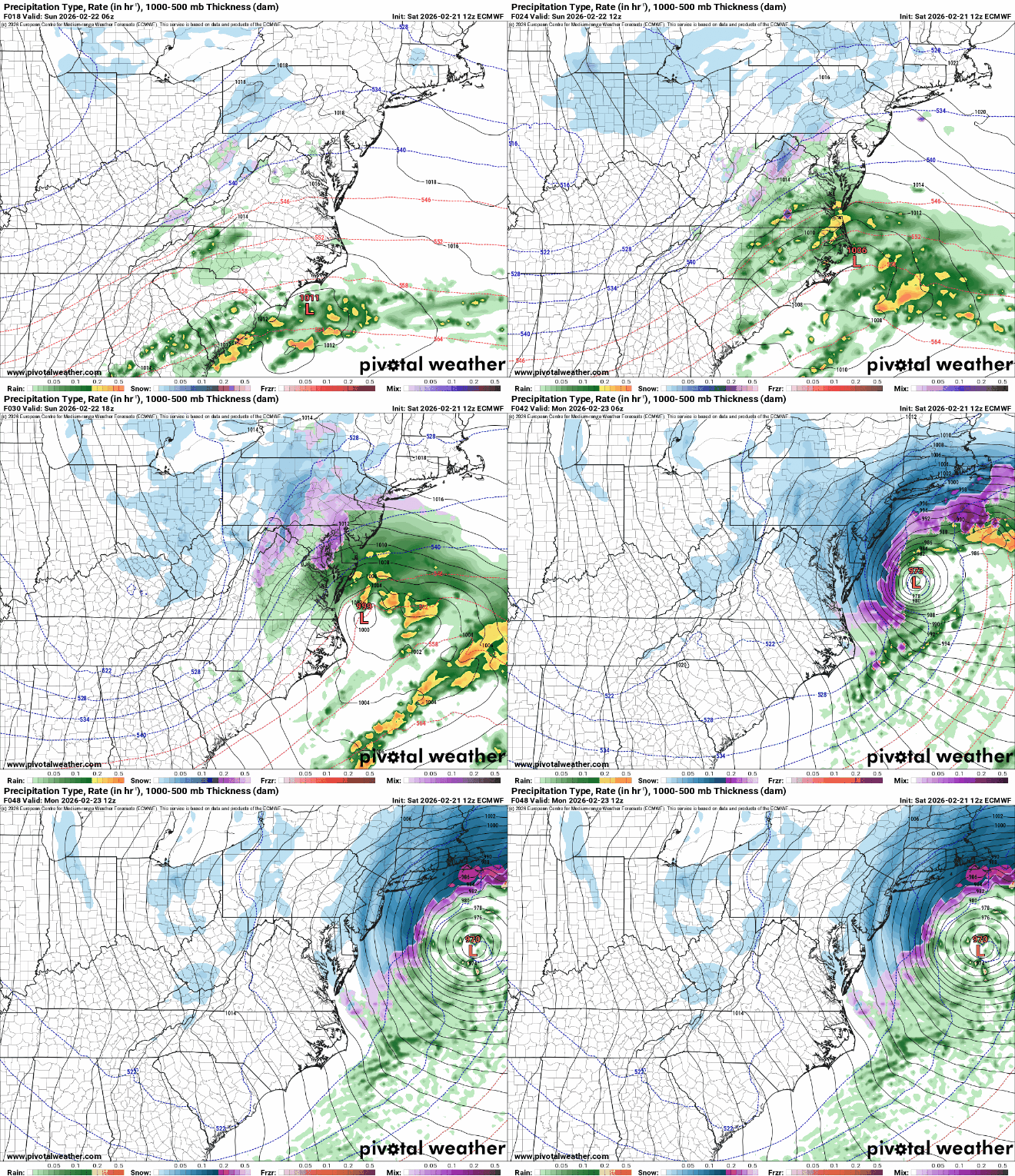
The ECMWF model shows rain starting early tomorrow morning before transitioning into snow later in the afternoon. Additionally, the low-pressure system is further away from the coast in this model. The snow would leave our area according to this model early Monday morning. In this model, the upper-wave trough will begin to transition into a slightly negative tilt from a neutral tilt, signaling the changeover from rain into snow.

Via www.pivotalweather.com
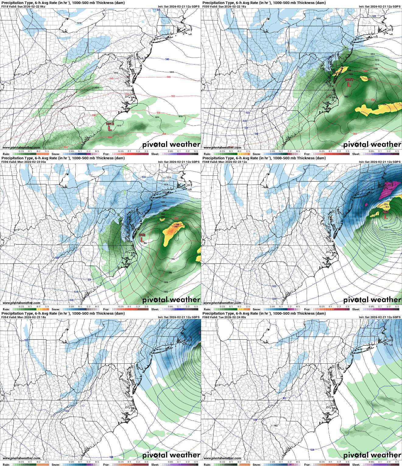
Finally, the GDPS shows snow starting tomorrow afternoon, and being less intense than the other two models in the College Park area. Our neighbors on the Eastern Shore appear to get the heavier snow. Like the ECMWF, the placement of the low-pressure system is further out to shore, and our area receives some rain before the snow. The upper-level trough stays neutrally tilted, then becomes slightly negatively tilted around the afternoon tomorrow. The snow clears up on Monday morning in this model as well.

Via www.pivotalweather.com
Nonetheless, the current model runs of this system suggest a messy and hazardous morning commute for Monday. Be sure to stay warm and watch for dangerous road conditions. As this is a constantly evolving system, the forecast could change with each additional model run. We suggest keeping an eye on forecasts as they update!
That’s all for today. Have a great day, Terps!
Writer: Anjali Vidyasagar
Editor: Frances Schoenly
Featured image via Anjali Vidyasagar
