
We hope everyone enjoyed their weekend! This week, the College Park and surrounding area will experience much milder weather this week compared to what we’ve experienced so far this semester.
Additionally, we’d like to take a moment to celebrate 11 years of Weather Writers! The first forecast article was put out on February 15, 2015, by Cory Martin. Thanks for reading our forecasts!
Today:
As the chilly rain from yesterday and last night clears out, morning commuters exercise caution and watch out for patchy fog, especially in the early morning. The day begins with chilly temperatures in the mid to upper 30s. By noon, temperatures rise to the lower 40s and reach a daytime high in the upper 40s. A gentle breeze will blow throughout the daytime and calm around sundown. Expect cloudy conditions throughout the day, with a few chances for some sunshine in the late afternoon.
Tonight:
Be prepared for a chilly night. Temperatures fall into the upper 30s throughout the night. Breezes remain in the 0 to 5 mph range.
Tomorrow (Tuesday):
Our skies are expected to clear up, so expect partly sunny skies throughout the day. Morning temperatures start in the lower 40s and rise steadily throughout the day to the mid 50s by the late afternoon.
Looking Ahead:
The remainder of the week is looking much milder; expect our area to experience the same daytime pattern of morning temperatures in the mid 40s and afternoon highs in the mid to upper 50s. If you’re making end-of-week plans, cloudy skies and showers are possible Thursday night and into Friday, but continue to monitor the forecast as we approach the end of the week.
Discussion:
Compared to the first few weeks of the semester, the cold stretch that College Park and the rest of the Eastern U.S. have been experiencing is finally out of the way. It’s possible that we could experience one or two more cold stretches before the end of winter, but, for the time being, we have a bit of a break from the cold.
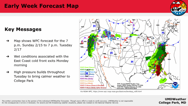
Yesterday, a low-pressure system rolled up from the southern east coast and brought the showers from yesterday evening and night. Discussions regarding this particular system had originally forecasted this to be a freezing rain/wintry mix, but the lower-altitude and surface temperatures weren’t cold enough to keep anything frozen at the surface. Regardless, temperatures were still chilly, and we were hit with a rather miserable period of rain.
As this system exists, some lower-level moisture will persist. With temperature inversions in the morning and the colder morning air, there is a possibility that the early hours could experience some patchy fog in areas surrounding the College Park area, so be sure to pay special attention to commuting conditions and exercise caution when making it onto campus. This should clear out by the late morning, and we can enjoy chances for some spots of sunshine in the afternoon.
After the low pressure system associated with the Sunday rain leaves, a high pressure system builds up at the surface. This system should linger and introduce milder temperatures on Tuesday before moving offshore on Wednesday.
For the remainder of the week, our area will experience two chances for warm air, both as a result of warm fronts passing over our area. Our first warm front passes over on Wednesday. A low pressure system building in the Midwest will bring the second warm front on Friday and, with it, warmer temperatures and moisture up from the gulf. As this front passes, the College Park area could experience showers on Friday, continuing into Saturday morning. However, continue to monitor the weather closer to the end of the week in case of any changes to the forecast.
Hopefully, the milder temperatures this week, coupled with the various periods of rain that we’ve had so far, could help melt some of the snow on campus.
That’s all for the early week. Best of luck to everyone!
- Writer: Frances Schoenly
- Editor: Anjali Vidyasagar
Featured image via Madison Magaha