
We all hope you are enjoying the snow days! Expect frigid temperatures for the remainder of the week into the weekend.
Today:
Morning temperatures start in the lower teens before gradually reaching a high temperature around 20 degrees in the late afternoon. Early evening temperatures will drop back into the lower teens. Winds will be in the 5 to 10 mph range, and we should expect cloud cover increasing throughout the day. Wind chill will make temperatures feel like they are in the single digits! Due to this, it is very important for everyone to dress warmly and try to limit the amount of time spent outside. Snow/ice around campus may still be slick, so be sure to watch where you are walking as well.
Tonight:
Temperatures overnight will reach about 5 degrees, with light and variable winds.
Tomorrow (Friday):
Our Friday morning temperatures will kick off in the mid-teens. Afternoon temperatures will linger around the lower 20s. After this, evening temperatures will drop back into the mid-teens. Expect light and variable winds and partly cloudy conditions.
Looking Ahead:
Weekend temperatures will remain frigid, with high temperatures expected to hover in the upper teens to lower 20s. We are keeping an eye on a potential winter weather system, which will be explained more in the discussion section of this article. Windier conditions will return to the area come Sunday.
Discussion:
After a widespread, destructive winter storm followed by frigid conditions in many parts of the country, there has been talk about another winter weather system impacting the Mid-Atlantic and Northeast U.S. this weekend. While this is a constantly evolving system, we will give our thoughts on the most recent run of the GFS (American) and ECMWF (European) weather models.
In terms of the synoptic weather set-up, a large, deepening trough will transition from being positively to neutrally tilted at the start of the weekend. Surface low pressure systems typically develop ahead of a trough, where upper-level divergence (spreading out of winds) and lower-level convergence (coming together of winds) occurs. This is what we see happening as the trough axis tilts, placing the developing coastal low pressure system off the Southeastern U.S. coast.
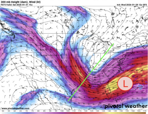
Via www.pivotalweather.com
The green line represents the positively tilted trough axis, while the red circle represents the developing coastal low pressure system.
Both models show the coastal low taking a northeastern path; however, the exact behavior of the coastal low can certainly change as we are still a couple of days away from the weekend. The GFS model has the low bringing snow to the Carolinas and eastern Virginia before grazing the sides of Maryland’s Eastern Shore, Delaware, New Jersey, and New York. College Park and the rest of the state west of the Chesapeake Bay miss the snow. As it moves into the North Atlantic ocean, it brings some snow to Rhode Island and Massachusetts.
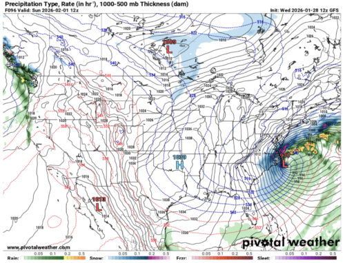
Via www.pivotalweather.com
The European model shows similar areas being impacted by snow from the coastal low (namely the Carolinas and Virginia), while also being more generous with lighter snow impacting the Eastern Shore, Delaware, New Jersey, and New York. Similar to the GFS model, Rhode Island and Massachusetts receive some snow as well. As of right now, both models show a low chance for weekend snow in College Park.
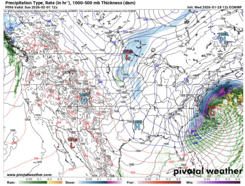
Via www.pivotalweather.com
This is where the ECMWF model placed the snow associated with the coastal low at the same time on Sunday morning.
As previously mentioned, this is a constantly developing system which will continue to change as we approach the weekend, so be sure to continue checking the forecast!
That’s all for today. Have a great day, Terps!
- Writer: Anjali Vidyasagar
- Editor: Morgan Peterson
Featured image via Anjali Vidyasagar