
Happy New Year, Terps! Today marks the beginning of a warm spell that will last throughout the weekend. Be sure to anticipate the mildest temperatures and showers on Friday and Saturday.
Today:
Expect mostly sunny skies and breezes throughout the day. The morning begins with temperatures in the mid to upper 40s. As the day progresses, temperatures rise and reach a daytime high in the mid to upper 50s. A considerable breeze around 10 mph builds into the afternoon. Wind gusts around 20 mph are expected in the late afternoon and are possible until sunset. Overall, with the milder temperatures, you can bring out your light jackets from fall and enjoy a break from the cold.
Tonight:
Chilly conditions briefly return tonight. Breezes die down to around 5 mph at sundown and temperatures drop into the lower 40s as the night progresses. Temperatures into early Thursday morning linger in the high 30s.
Tomorrow (Thursday):
Another mostly sunny day is expected on Thursday with morning highs in the 40s. Afternoon temperatures rise into the lower 50s. Winds should not be too noticeable today and are expected to remain below 5 mph throughout the day. As the sun sets, calm conditions persist, and temperatures drop into the lower 40s.
Looking Ahead:
Friday and Saturday will feature the warmest temperatures this week, with daytime highs in the upper 50s and lower 60s on Friday and in the mid 60s on Saturday. Winds should remain in the 5 to 10 mph range with gusts in the afternoon for both days. Chances for some showers begin on Friday, but expect most showers and rain to appear during the daytime on Saturday. The rain should stick around Saturday night before moving out of the area by Sunday. By this point, we return to chilly, winter temperatures. In summary, expect to feel much warmer and make sure to keep an umbrella handy on Friday and Saturday.
Discussion:
Seeing 60 degrees in January is definitely odd!
Today, a surface high pressure system builds throughout the day. In the morning, a passing cold front over early Wednesday morning brings stronger winds behind it as it passes. As we progress into Thursday, stronger northwest winds shift to weaker southwest winds at the surface as the surface high pressure builds.
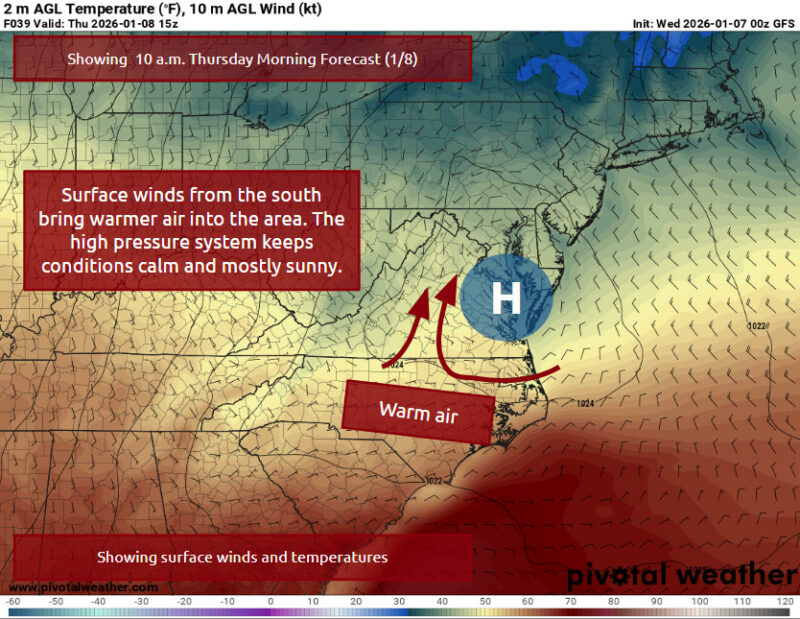
Via www.pivotalweather.com
As we approach Friday and Saturday, the high pressure moves offshore, and an incoming low pressure from the central and southwest US moves towards the northeast Canada area. As this low pressure moves northeast, a cold front extends south from the system. This front should pass over our area Friday afternoon and evening, which will be responsible for the showers and rain we will see around this time. Warm air advection from the southeast will supply this system with warmer temperatures and moisture alongside the lifting from the cold front should make a few light showers possible in the afternoon.
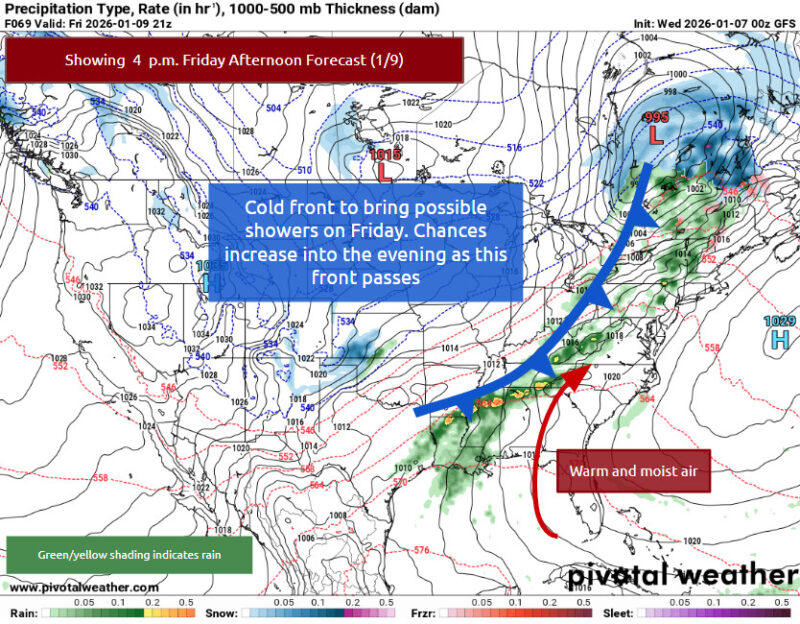
Via www.pivotalweather.com
With the high pressure system offshore to our east and lower pressures to our west, this setup will help pull warmer air and considerable amounts of moisture from the Gulf over the D.C. area. A low pressure system and cold front approaching from the west will lead to lifting ahead of this front, which will contribute to the showers that our area will experience on Saturday afternoon into early Sunday morning.
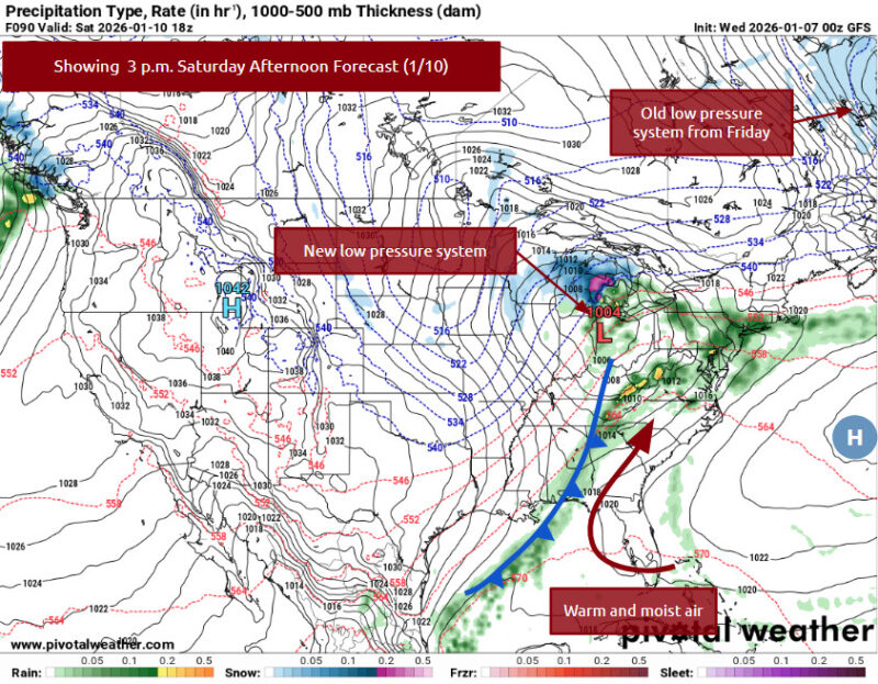
Via www.pivotalweather.com
This cold front finally passes over our area midday/afternoon on Sunday, and our area will return to winter temperatures.
We hope you have a restful week, Terps! Definitely try to get some sunshine with the warmer air today and tomorrow, and stay dry this weekend.
- Writer: Frances Schoenly
Featured image via Frances Schoenly