
This forecast has since been updated as of 2025-12-04 21:38:55
Expect the arrival of some colder temperatures to end your week, along with the possibility for some flurries on Friday.
Today:
Morning temperatures start in the upper 20s to low 30s. Temperatures peak around the mid-40s, before dipping back into the mid-30s. Winds will be 10 to 15 mph throughout the day, with the possibility of gusts over 20 mph. Cloud cover will increase as the day progresses.
Tonight:
Be sure to stay warm this evening! Nighttime temperatures are expected to be in the low-to-mid 20s. Winds will become light and variable.
Friday:
There’s a chance for some snow accumulation arriving Friday morning, with total snow amounts range from a light coating to up to 2″ of snow. Be sure to keep an eye on the forecasts as they update! Our Friday will kick-off with temperatures in the mid-20s, before slightly increasing into a daytime high around 30 degrees. Evening temperatures will drop into the upper-20s. Light and variable winds continue throughout the day.
This forecast has been updated; changed forecasts have been bolded both in the main weather report and in the forecast discussion. The original forecast predicted evening flurries, but more recent events and guidance forecasts currently call for an earlier arrival of higher amounts of snow accumulation. Expect anywhere from a small coating up to 2″ of snow to fall early Friday morning. Stay tuned for an updated article.
Looking Ahead:
Weekend temperatures should stay in the 40s range, and partly cloudy conditions will likely continue to dominate. Winds will continue to stay light and variable.
Discussion:
How possible would it be for us to see some snow on Friday? Between now and Friday, the exact timing and location of possible winter weather in our area is still variable, so keep a look out for updated forecasts! However, we can consider what ingredients are in place for snow. Temperatures throughout the day on Friday are predicted to be below freezing, which means that it would be cold enough for snow. The low-pressure system that is bringing with it our next chance for snow is coming up from the Gulf Coast, as seen in the picture below. Currently, the snow is predicted to stay to the south of us for a majority of the day, and our best chances for potentially seeing some flurries would be towards the evening.
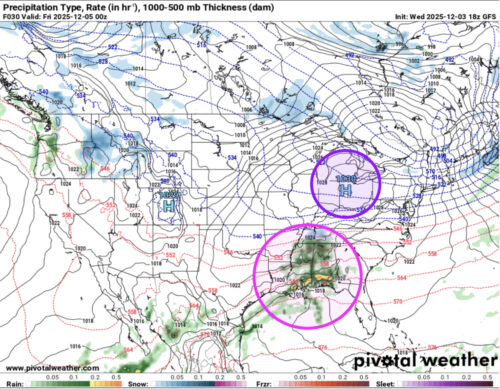
Via www.pivotalweather.com
The predicted location of the low-pressure system (pink circle) and high-pressure system (purple circle) by this evening.
While this low-pressure system is bringing moisture, the high-pressure system to the north of us is supplying drier air into our area. This dry air would limit the low-pressure system and snow from trekking further northward to us, as it limits the amount of overrunning of warm over cold air. Ultimately, our chances for seeing snow depends on how far north the high-pressure system moves by the time the low-pressure system comes into our area on Friday.
That’s all for today. Have a great day, Terps!
- Writer: Anjali Vidyasagar
- Editor: Morgan Peterson
Featured image via Anjali Vidyasagar