
Colin Brown
Halloween is typically associated with cool conditions for this time of year, and this week’s weather is eager to play the part. Average and cooler than average temperatures persist throughout the rest of the month, and all eyes are on tomorrow’s storm system that could deliver the most rain in our area we’ve seen in a while.
Today (Wednesday):
We’re looking at cloudy skies dominating a cool day. The clouds will likely persist throughout the entire day. There is also a slight chance of showers or light rain, but amounts should not be significant. Highs reach the upper 50s in College Park, with some potentially reaching closer to 60 as we move southward, so definitely layer up. A slight breeze may make it feel a bit colder, but not significantly so.
Tonight:
Rain arrives a couple hours before midnight and picks up intensity as the night goes on. There will likely be breaks in the precipitation, but moderate to heavy rainfall are expected to come in short bursts. Total amounts could reach from a half inch up to an inch in localized areas. Lows around 50 are not a significant drop from today’s high temperature.
Tomorrow (Thursday):
Periodic bursts of moderate to heavy rainfall are expected to continue, but should gradually taper off and end by mid to late afternoon. Total precipitation amounts could be 1.5 to 2 inches area-wide, with slightly more rainfall for western parts of the region. Clouds will still be stubborn, but temperatures will be warmer compared to today, with highs into the 60s.
Looking ahead:
Just in time for Halloween, the weather cooperates. This weekend will feature lots of sunny skies, highs in the low 60s (average high is around 64), and lows in the high 30s to low 40s. Trick-or-treaters won’t have to worry about any rain, but it will come with a typical night chill. Next week is uncertain, with more chances of rain around a week from now. In the long range, there do not seem to be strong indicators of warmer or cooler than average temperatures, so expect highs to be in the upper 50s to mid 60s.
Discussion:
In regards to this week’s rainfall, no huge forecast changes have occurred since Donovan’s Morning Update yesterday, but the general consensus is more slightly more rain for the region than model forecasts yesterday.
In winter, this would be known as an “Appalachian runner” with the low to our west. Our region is in the “warm section” of the system- to the east of the low, rain is often more showery and less steady but periodically heavier. Thunder is even possible due to this system. Though the low pressure is not particularly strong and is not a nor’easter, significant rainfall is still expected due to the strength of the trough, currently in the Southeast. The storm will also help push hurricane Melissa away from the U.S. after its push through Cuba and the Bahamas, but not after a catastrophic and devastating category 5 landfall in Jamaica today.
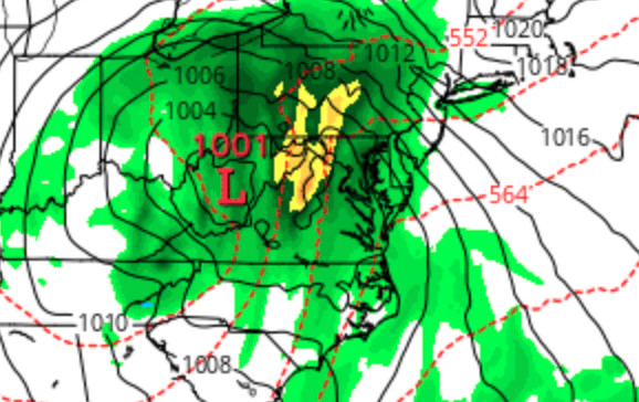
The low pressure system over West Virginia, with the heaviest rains to its east.
Here are model forecasts for the rain event (tonight+tomorrow):
German: 1.4 inches
GFS: 1.5 inches
Euro: 1.6 inches
NAM: 1.7 inches
Canadian: 1.8 inches
UK: 1.8 inches
The significant rain in a short amount of time could cause localized flooding in poor drainage areas, despite soils being relatively dry. However, in areas where flooding does not occur, this rainfall will be beneficial- Abnormally dry or drought conditions have crept back into the area, after a dry October. Storms have just kept missing us (like the one to our South Donovan mentioned yesterday) or underperformed. It is looking like that steak will finally end.