
Today:
Morning temperatures will be starting out in the mid-40s and increase to an afternoon high of around 60 degrees. After this, temperatures will lower into the mid-50s by early evening. Winds will be in the 5 to 10 mph range. Expect sunny skies with some passing clouds in the area.
Tonight:
Nighttime temperatures will be in the mid-40s range. These low temperatures will be accompanied by light and variable winds and clear skies.
Friday:
Temperatures will hover in the low-to-mid 40s in the morning before rounding out to a daytime peak in the high 50s. Early evening temperatures will drop down into the mid-50s. Winds will once again be in the 5 to 10 mph range. Expect mainly sunny skies with some clouds developing in the afternoon.
Looking Ahead:
Get ready for a beautiful weekend here at College Park! Temperatures will stay in the low 60s, with partly cloudy skies heading into and throughout the weekend.
Discussion:
We are staying dry and cool for the next foreseeable days, why is that so? High pressure is dominating the weather story for the remainder of this week and into the weekend, which is associated with a net downwards motion of air and stable atmospheric conditions. Although there is a cold front passing through our area, it will only bring in some clouds and cooler temperatures as we enter the weekend.
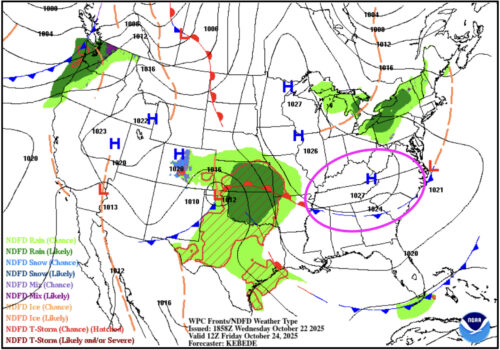
Via www.wpc.ncep.noaa.gov
In the above surface fronts map, you can see the high pressure system and cold front setup that is in place for Friday. Enjoy this pleasant fall weather!
That’s all for today. Have a great day, Terps!
- Writer: Anjali Vidyasagar
- Editor: Morgan Peterson
Featured image via Naomi Feldman