Today:
Morning temperatures will start off in the high 40s, which peak in the high 50s by the afternoon. The early evening will see temperatures slowly drop back into the high 40s. While the day begins rather sunny, clouds will come into the region as the day progresses. Winds will be between 10 to 15 mph, with gusts around 25 mph.
Tonight:
Cloud cover will increase throughout the night, with a low temperature around 40 degrees. Winds will be light and variable.
Wednesday:
Temperatures will be similar to what we are seeing today. Morning temperatures start around the low 40s, which eventually reach a high in the mid to high 50s. Throughout the early evening, temperatures will stay in the high 50s. Winds will be in the 10 to 15 mph range, with some gusts around 25 mph. With partly cloudy skies, it looks like we will have another beautiful spring day!
Looking Ahead:
For the rest of the week, high temperatures will be in the high 70s to low 80s, while low temperatures will be in the high 50s to low 60s. There is a chance for rain throughout the rest of the week, while Thursday night could see some thunderstorms.
Discussion:
As we get further into spring, it seems like we get these sudden heavy/severe thunderstorms. Even at some point in the summer, it feels like we get a thunderstorm around the same time everyday. What’s up with that??? Basically, warm temperatures heat the ground, which warms the air right above the ground via conduction (or heating through direct touch). This creates a parcel of warm air that is hotter than its surroundings, as well as lighter/denser, so it rises further into the atmosphere. As long as the air parcel is warmer than the surrounding air, it will keep rising, which is a characteristic of an unstable atmosphere. If the parcel rises to a certain point where it can condense into a cloud, thunderstorms can eventually be created if the atmosphere continues to be unstable, allowing for the process to continue.
Typically, these rising air parcels that eventually form thunderstorms are assisted by lifting mechanisms which force air upwards. In this week’s case, a warm front will likely glide over the area on Wednesday. Warm fronts involve the overrunning of cold air over warm air, resulting in steady, large-range showers. These showers are expected around Wednesday night. Following Thursday, another day with highs in the 80s expected, there is similarly a potential for thunderstorms in the evening resulting from those hotter temperatures.

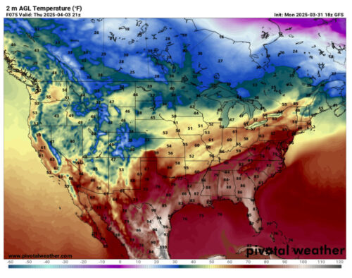
Via www.pivotalweather.com
This is the temperature map for Thursday evening, around when the next batch of thunderstorms may occur. In Maryland, the red coloring indicates warmer temperatures in the mid to upper 70s.

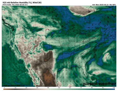
Via www.pivotalweather.com
This is the humidity map for the same time on Thursday. Humidity measures moisture in the atmosphere. On this map, high humidity values are indicated by darker shades of green and blue, which is what our area is colored as. With warm temperatures and high moisture, there is a chance for another round of storms this week. Let’s see what happens on Thursday!
That’s all for today, have a great day Terps!
- Writer: Anjali Vidyasagar
- Editor: Frances Schoenly
Featured image via Anjali Vidyasagar
