
Today:
We hope everyone had a nice and restful spring break! Although we kicked off the week with some rain showers yesterday, today we can expect to have dry conditions. Winds will be in the 5 to 10 mph range, with the possibility of gusts around 20 mph. Temperatures will start in the mid 40s and reach a high in the low 60s by the afternoon. Early evening temperatures will move back into the low 50s. Clouds will move into the area as the day progresses.
Tonight:
We may see some scattered showers throughout the evening, which should clear out by the morning. Temperatures will be in the high 30s to low 40s. Winds will be light and variable.
Wednesday:
Like the rain, any clouds from the evening will clear out by the morning. Temperatures will be in the low to mid 40s, climb into the mid 50s by the afternoon, then drop back into the low to mid 40s range come evening. Once again, winds will range between 5 to 10 mph. Looks like another pleasant day in College Park!
Looking Ahead:
High temperatures will stay in the upper 50s to low 60s range throughout the rest of the week. Low temperatures will stay rather chilly in the high 30s to low 40s range. After tonight’s rain, we are looking at a sunny and dry remainder of the week. Expect sunny conditions throughout the week with clouds entering the region towards the end of the week. In between watching March Madness and cheering on the Terps, make sure to get outside and enjoy the weather
Discussion:
The dreary, rainy conditions we saw for the majority of yesterday, along with the potential rain this evening, are products of the competing warm and cold air masses above us in the atmosphere. The boundaries where these air masses meet, or fronts, are what create weather like rain. This is why we sometimes see small-scale, localized rain showers that seem to come from nowhere (except now you know they can come from frontal systems!). For this week, a double dose of cold fronts are sweeping into the region. The first cold front already made its way through the area yesterday afternoon and brought with it a weaker high pressure system. The second cold front is arriving this evening/early Wednesday morning and brings a stronger high pressure system that stays in the area for the remainder of the week, hence the sunny, dry weather.
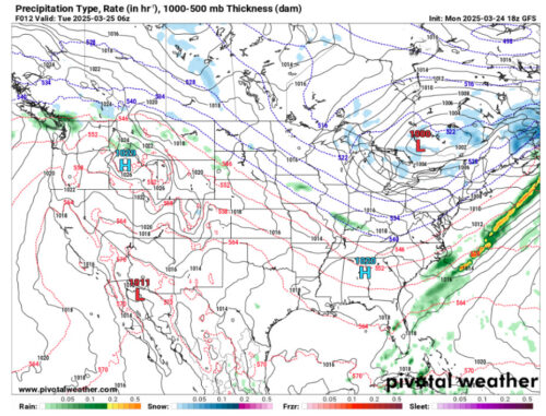
Via www.pivotalweather.com
As we are under the weaker high pressure system at the moment, our pressure values are in the 1012-1014 mb range.
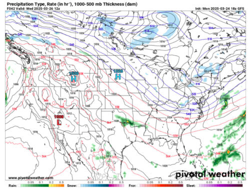
Via www.pivotalweather.com
This is the map for Wednesday after the second cold front moves out of the area. Being under the stronger high pressure system, pressure values are in the 1018-1020 mb range.
That’s all for today, have a great day Terps!
- Writer: Anjali Vidyasagar
- Editor: Frances Schoenly
Featured image via Anjali Vidyasagar