
Today:
Today will be dry with partly sunny skies! Foggy and overcast conditions will persist through the morning before gradually clearing in the afternoon, allowing for some sunshine and partly cloudy skies. Temperatures will start in the low to mid 40s, warming into the mid 50s, with a daytime high in the upper 50s. Winds will remain light at 4-6 mph, with occasional gusts up to 10 mph.
Tonight:
Temperatures will gradually fall into the low 50s and mid 40s before reaching an overnight low in the low 40s. Winds will stay calm at around 5 mph. Clouds will begin moving in around 7 p.m., bringing overcast skies and foggy conditions through the night.
Saturday:
Overcast skies will persist throughout the day, making for a cloudy and warm forecast. Temperatures will start in the mid 40s, climb through the 50s, and reach a daytime high in the upper 60s. Winds will stay light at 5-10 mph, picking up slightly from Friday, with gusts up to 15 mph.
Looking Ahead:
Looking ahead to the rest of the weekend, Sunday will bring showers with breezy winds and temperatures reaching the low 70s. Early Monday, expect scattered morning showers and increasing winds as temperatures drop into the low 60s. By early next week, skies will clear, bringing sunshine and a return to the low 70s.
Discussion:
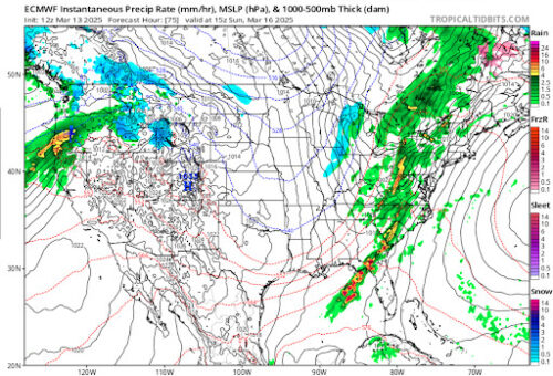
Via www.pivotalweather.com

Via www.pivotalweather.com
The first screencap shows precipitation on the radar around 10 a.m. on Sunday, while the second screencap, taken at the same time, displays 250mb vorticity and wind. Vorticity measures how much air is spinning vertically in the atmosphere. Areas of positive vorticity indicate rising air, which can lead to cloud development and possible storms, while negative vorticity suggests sinking air and more stable conditions. The showers expected on Sunday and Monday are primarily due to a large-scale upper trough moving from the Mississippi Valley toward the Appalachians. This system will bring strong south-southwesterly flow due to a tight pressure gradient between the strong low and a high pressure positioned offshore, increasing moisture and instability (aka the recipe for convection!).
At the same time, a cold front from a developing low-pressure system over the Great Lakes will move through the region on Sunday (see below).
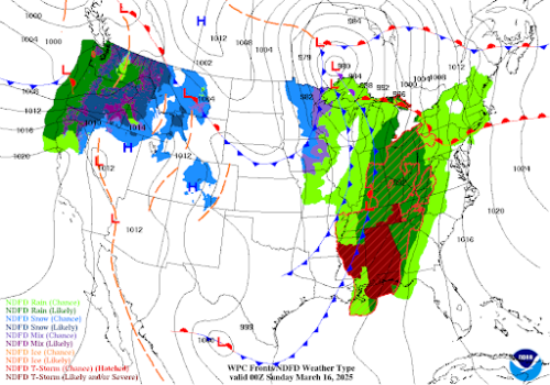
Via https://www.wpc.ncep.noaa.gov/basicwx/basicwx_ndfd.php
Ahead of this front, strong southerly winds will bring warmer, more humid air, allowing temperatures to climb into the upper 60s and low 70s. Winds are expected to be breezy, with gusts in the 20-30 mph range, especially at higher elevations. While this system has the potential to bring heavy showers and even thunderstorms, the severity will depend on whether enough instability develops ahead of the front. Current model guidance suggests limited CAPE, meaning the risk for severe storms is low but not zero. However with high moisture levels, any showers or storms that do develop could produce heavy rainfall in a short period, especially in urban or poor drainage areas, so stay safe, Terps!
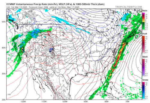
Via www.pivotalweather.com
By early Monday morning, the system will move offshore, bringing in much drier and cooler air. Northwest winds will pick up, with gusts around 20-25 mph, and temperatures will drop into the high 50s and low 60s for the day as the cold front moves through our region as well. Looking ahead to next week, a high pressure system will build in, bringing back dry and warm conditions. Temperatures will climb back into the mid to upper 60s on Tuesday and could even push near the low 80s by Wednesday as a strong upper-level ridge moves in!
That’s all for today, Terps, and have a great spring break!
Writer: Madison Magaha
Editor: Frances Schoenly
Featured image via Frances Schoenly