
Today
Be ready for cloudy and breezy conditions today! Temperatures start in the lower 40s at sunrise and will climb to the upper 40s and lower 50s by the afternoon. We’ll have some cloud cover for most of the day before clearing up around sunset. However, the star of the show today will be the winds. Morning winds start as moderate 10 to 15 mph breezes before strengthening to around 20 mph in the afternoon. Expect morning gusts in the 20 to 30 mph range and afternoon gusts in the 30 to 40 mph range. Peak gusts around 45 mph are expected in the early afternoon.
Tonight
Winds die down slightly, but conditions remain breezy. Be prepared for breezes around the 15 mph mark and gusts around 25 mph until midnight. Temperatures will drop into the mid 30s throughout the night and into the early morning.
Friday
Friday is on track to be a sunny day! Temperatures will rise from the mid 30s to the lower 50s in the afternoon. Some breezes around the 10 to 15 mph range are expected before lunchtime but should settle into a calm breeze in the evening.
Looking Ahead
The start of this weekend is looking to be relatively uneventful. We’re on track for partly cloudy skies, temperatures in the upper 40s and lower 50s, and gentle breezes on Saturday. On Sunday, we can expect mostly sunny skies and temperatures warming up to the upper 40s and lower 50s.
Discussion
Hopefully, you all were able to stay dry yesterday! The windy and slightly cooler conditions we’ll be seeing today are largely due to the exit of the low-pressure system that brought us the storms yesterday. As this system exited up through Quebec, the cold front associated with the storms yesterday passed through our area last night and early this morning. Once the front has fully moved on, we’ll experience chillier temperatures compared to the last few days.
But just as this system trails northward, we also find ourselves caught in the middle of a sizable pressure gradient. High pressures from our west equalize with the low pressures on our side of the country.
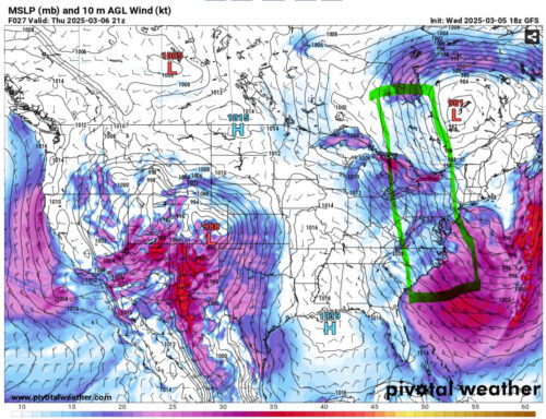
Via www.pivotalweather.com
This map shows MSLP (Mean Sea Level Pressure) and wind according to the color gradient at the bottom. The highlighted green box shows where the pressure gradient is relatively strong and where we can expect some of the strongest winds. As you can see, our area falls within this area of concern.
Quick weather tidbit! We throw around the term “pressure gradient” quite a bit. When we refer to a pressure gradient, we’re referring to areas where these pressure lines are close together on maps like the one above. In between pressure gradients, our atmosphere is attempting to “equalize” the pressure differences and will try to move air from areas with high pressure (i.e., areas with a lot of air) to areas with low pressure (i.e., areas with not a lot of air). In this equalizing process, air is moved. We know this phenomenon of moving air as, you guessed it, wind! So, in areas with high-pressure gradients, we typically experience the highest winds.
You can see this happening on the map above! Notice how the wind barbs (the little arrow things) point from the high-pressure areas towards the low pressure.
Anyway, hopefully, you can leave this article with some new weather knowledge. Now you know why wind happens!
To finish out the weather discussion, this low-pressure system will continue to exit, and the high pressures to our southwest will move into the College Park area around Friday. This will bring some of the nice weather we’ll see that day.
We’ll continue to keep you all updated with the weather as we finish out this week. Hold onto your stuff and finish this week strong!
Written by: Frances Schoenly
Edited by: Alexander Wang
Featured image by: Frances Schoenly