
Today:
College Park will have a chilly, sunny, and relatively uneventful day today. Morning temperatures begin in the upper 20s and progressively climb to the upper 30s and 40s around lunchtime. For the rest of the day, we expect temperatures in the low 40s from late afternoon until sunset. Expect a light breeze throughout the day, with winds at or below the 5 mph mark during the daytime. Be sure to bundle up and dress cozy as you walk to classes!
Tonight:
Expect, like the daytime, a calm evening and night. At sunset, temperatures gradually fall to the mid 30s in the evening and into the low 30s by midnight. Winds will stay calm. We could see some more cloud cover building throughout the night.
Tuesday:
We’re expecting a warmer day with partly sunny conditions! The morning begins in the upper 30s before warming up to the mid 50s by noon. Into the afternoon, we could see a daytime high in the upper 50s and possibly in the lower 60s. We’ll be seeing some breezes tomorrow; the day will start with winds around 5 mph before climbing to the 10 mph mark in the late afternoon.
Looking Ahead:
The rest of the week is looking to be quite eventful! After the nice weather today and tomorrow, we’re expecting temperatures in the 50s and 60s with steady rain throughout most of the day on Wednesday. Additionally, there are some good chances for some thunder in the afternoon and evening. The rain should clear out by Wednesday night and make way for a windy Thursday. Thursday temperatures are expected to be in the mid 40s and 50s with winds in the 15 to 20 mph range.
Discussion:
We’re looking forward to seeing a wide variety of weather this week; we’re going from chilly, to bearable, to possible thunderstorms, to blustery winds, and finishing off with a pleasant day on Friday.
Starting with the Monday weather, we remain under and within a high-pressure system for most of today. It’ll hold onto some of the cold air we’ve seen over the weekend, but it’ll move offshore by Tuesday. With the exit of this high-pressure system, we’ll see the winds pick up and flow out of the system to our west. Some warmer air will start to creep up to the Washington D.C. and College Park area with the exit of this system, as well.
Overall, the weather is nothing too eventful. Just to visualize everything I said above, here’s what our temperatures and pressures will look like around 2 p.m.:
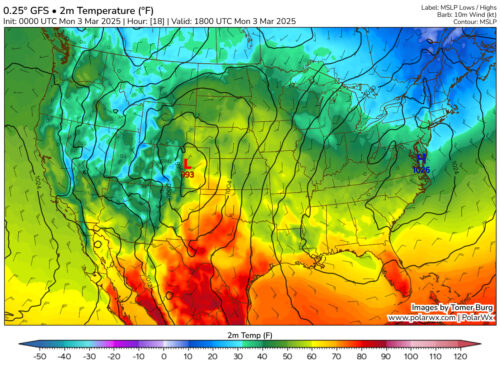
Via www.polarwx.com
However, if you notice, there is a low pressure off in the western United States. This low pressure will be the culprit for the rain (and possible thunderstorms) we’ll see on Wednesday.
This particular system, though, is stronger than some of the other systems we’ve seen this season and is expected to bring severe weather to many parts of the United States. As of writing this article, the GFS model (a type of computer model used in predicting the weather), shows the lowest pressure of this system as 980 mb as it crosses over Missouri. Had this system appeared in the tropics or the Gulf, it would have been classified as a tropical storm or a Category 1 hurricane, with the right conditions. Hopefully, this comparison puts the strength of this system in perspective.
Many parts of the country are preparing for intense winds, thunderstorms, hail, snowstorms, and, in some parts, possible tornadoes with the passage of this system. The Louisiana-Arkansas-Mississippi area is currently being advised to keep an eye out for tornadoes on Wednesday. If you’re curious about the severe weather across the country this week, you can explore the outlooks on the NOAA Storm Prediction Center website.
For now, we’ll focus on the severe weather we’ll see as a result of this particular low-pressure system. Currently, we’re under the radar for a slight risk of thunderstorms on Wednesday.
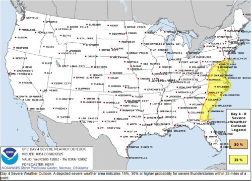
Via spc.noaa.gov
Here is the radar around that time, just to show where the storms are:
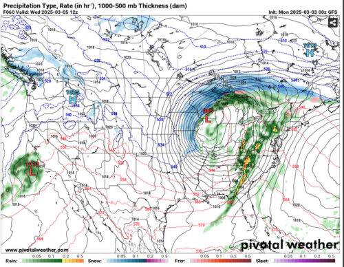
Via www.pivotalweather.com
This is very interesting! We don’t usually see thunderstorms in winter. For now, we can expect rain on Wednesday when this band of storms passes through. Also, the winds will pick up as this system exits Thursday into Friday. It would probably be a good idea to find your rain jackets or umbrellas before class on Wednesday and be prepared for a blustery Thursday.
On the plus side, we have a great start to the week with some nice weather, so be sure to take advantage of the sunshine and calm conditions today and tomorrow. To end on another good note, the rain we’ll see will bring some much-needed moisture to the area and hopefully alleviate some of the dry conditions we’ve been experiencing the past few weeks. We’ll be sure to keep you all updated as we approach the midweek, and we hope you have a great week of classes!
Written by: Frances Schoenly
Featured image via Frances Schoenly