
Today:
It’s going to be another beautiful day in College Park! Morning temperatures will start in the high 30s to low 40s, bringing clear and sunny skies. By noon, temperatures will climb into the high 50s, reaching a daytime high in the 60s. Expect partly cloudy conditions by the afternoon as the approaching low pressure system moves in, bringing a cloud cover of around 30-40%. As the early evening approaches, temperatures will dip into the low 50s, and cloud cover will increase to 50-60%. Winds remain calm and light around 5 to 8 mph.
Tonight:
Temperatures will stay in the mid 40s, so it’ll be a cool and comfortable night. Expect overcast skies with nearly 100% cloud cover. Winds will remain light and calm.
Thursday:
Expect a cloudy and humid morning, with temperatures in the high 40s to low 50s. Showers are expected to move in around late morning and early afternoon, bringing a daytime high in the mid 60s. Winds will be around 5 to 10 mph, with gusts up to 20 mph—because as if last week’s winds weren’t enough, right, Terps?!
Looking Ahead:
After Thursday’s showers, expect a break in the rain with drier conditions returning. Cooler air will move in, bringing temperatures back to seasonal averages. Expect sunny skies for the upcoming weekend. It will be perfect weather to get outside, Terps! Take advantage of it with a walk or bike ride.
Discussion:
What a beautiful change from last week’s windy and cold mess! The high pressure system responsible for this warm and pleasant weather will stick around through Wednesday, making it a great day to get outside.
By Thursday, things start to change as a warm front lifts north of us. This front is connected to a low-pressure system moving through the Midwest, pulling warm, moisture-rich air from the south. As it moves into our area, expect increasing clouds and some light showers. Most of the action will stay to our north in northern Maryland, so we’ll mainly see overcast skies and mild, scattered rain. Following the warm front, a cold front will push through, bringing on-and-off showers throughout the day on Thursday.
Once the system moves offshore Thursday night, cooler and drier air will settle in. So, enjoy the warm and dry weather while it lasts!
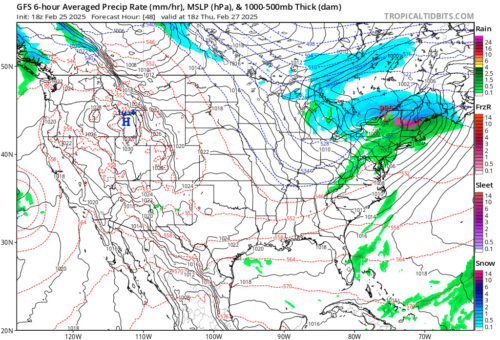
Via www.pivotalweather.com
This snapshot shows GFS radar projections around 1 p.m. on Thursday. As we can see, that low pressure system is not holding back on precipitation! Don’t forget your raincoat on Thursday, but make sure you dress light as temperatures will still be fairly warm.
Thanks for reading, and stay tuned for future updates!
Writer: Madison Magaha
Editor: Frances Schoenly
Featured image via Frances Schoenly