
This weekend:
We’re still on track for quite the soaking rain that will last a while going from late this afternoon (Saturday) into around midnight, before another brief round at midday tomorrow. It’s even possible that highs breach 60 before the cold front blasts through in the evening tomorrow as well. The cold this establishes into early next week will set the stage for perhaps more wintry precipitation!
Although rain totals could breach an inch in spots and the precipitation could be moderate at times, current guidance suggests that this will be spread out across the evening hours rather than occurring all at once. Flooding issues should therefore be minimal, besides the mountains out west where snowmelt may create a couple problems.
Looking ahead:
No weather to write home about early next week as the cold continues to linger & high pressure remains across the eastern half of the country. The topic of this article is, of course, snow – so let’s cut to the chase. An abnormally strong high-pressure system is forecast to develop across Montana as an arctic front plunges into the central Plains. An area of low pressure could track across the Gulf coast and strengthen offshore of the Carolinas. North of this low-pressure system, there will be precipitation, and combined with all the cold air in place – that’s why snow is a real possibility.
It’s too early to think about snow amounts or timing as there are still a lot of unknowns. However, the potential for a significant winter storm is certainly there, and that’s why our local National Weather Service office has already issued an “Enhanced” winter storm threat for both Wednesday and Thursday with potential impact maximized. Notice that the Weather Prediction Center also has a heavy snow threat area centered over us as well.
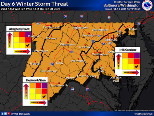
Via https://www.weather.gov/lwx/winterstormthreat
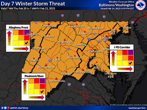
Via https://www.weather.gov/lwx/winterstormthreat
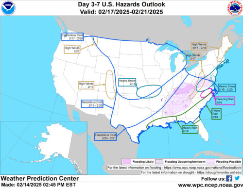
Via https://www.wpc.ncep.noaa.gov/threats/threats.php
Discussion:
Let’s first look on a large scale as to why models are showing a significant snow threat next week. This is a look at the upper atmosphere, and to put it simply, reds signify high pressure & blues low pressure. The first thing that catches my eye as a forecaster is all those reds in northern Canada and Greenland. This is what we call “blocking,” and it prevents any low pressure systems from going too far north and bringing us rain. Not only that, but it’s shifting southwest and weakening; that’s something that is often seen with some of our biggest snowstorms.
The other thing about this pattern is that huge, strong low pressure system off to the east. This is actually our system from this weekend, and its presence is important as the “50/50 low” (low pressure around 50 N, 50 W) to lock in our cold air.
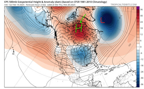
Via www.pivotalweather.com
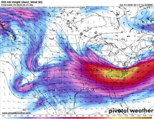
Now let’s get into the details. That streak of strong upper level winds will force low pressure to develop near the Florida panhandle coast, bringing forth plenty of moisture from the Gulf. The most important feature to watch out for though is that upper low in the Midwest – it’s a piece of the polar vortex forced southward by the high pressure blocking.

Via www.pivotalweather.com
As the low pressure area moves northeastward up the Atlantic coast, the main question is if and when it combines (or “phases”) with that upper low – this would improve the dynamics of the storm and allow it to snow heavier. The sooner it does so, the more potential for a hefty snow event here. Quite a few models are showing a phase, but there are also some that don’t. It’s just a wait and see situation.
Just as an example, the European model does combine the two pieces and does so quickly, too. Those strong upper level winds would force a strong low pressure system to develop with a ton of snow!
Via www.pivotalweather.com
That’s all for now. This weekend is great stay inside weather, and on Monday we should have a lot more clarity about this potential snowstorm. Stay tuned!!!
-Veer T
Featured image by Frances Schoenly