
Today:
Some chances for a slight drizzle in the morning as the rain from last night exits the area, but any precipitation should be out of the way by the early afternoon. Temperatures are looking warmer today compared to what we’ve seen this week. The day starts around the upper 30s and lower 40s before moving up to the upper 40s and even into the 50s in the afternoon. We’re looking at wind throughout the day ranging from 10 to 15 mph with some gusts in the afternoon. On the plus side, the clouds are expected to move out of the way before sundown, so we’ll see some sunshine before the sun sets.
Tonight:
The night is looking mostly clear as the sun sets and temperatures cool. Temperatures drop back down into the upper 30s in the early evening and into the mid to upper 20s as the night progresses. Winds stay relatively the same throughout the night at around 10 mph with the occasional gust here and there. The nighttime weather will be chillier than what we’ll see during the day, so dress warm out if you plan on being outside!
Friday:
Valentine’s Day is looking like a chilly and sunny day. Temperatures range from the lower 30s before topping off in the lower 40s in the late afternoon. We’ll see some breezy wind in the morning before calming down into the late afternoon and night. Evening temperatures are expected to stay in the mid 30s range.
Looking Ahead:
It’s looking like we’ll be seeing a rainy weekend. The rain is looking to begin on Saturday as a low-pressure system rolls through our area. Daytime temperatures for Saturday range in the mid to upper 30s. Into Sunday, temperatures are looking to warm up quite a bit, and we could see temperatures in the upper 50s. However, by the start of classes next week, we’re back to chilly winter weather.
Discussion:
The big topic of today is the temperatures. Seeing 50 degrees in February is quite a surprise!
Regarding what our atmosphere is doing, the low pressure that brought us the rain on Wednesday and into this morning moves to our northeast. As it moves, the system continues to drag warm air from the south into the College Park region.
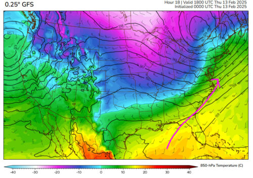
Via www.polarwx.com
This snapshot gives us an idea of the temperatures at around 5,000 feet in the air. This starts making a bit more sense if we take a quick look at the surface, with the high and low systems labeled:
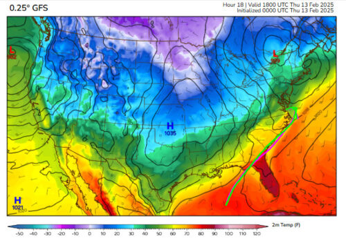
Via www.polarwx.com
By the time the high pressure enters, though, it’ll bring in a cold front, which will reflect in the chillier temperatures tonight and into Friday.
That’s all for the Thursday forecast! We hope you all have a nice return to classes after our snow day yesterday. As a side note, if you are ever curious about what temperatures are looking like around campus, you can check out the UMD micronet station map!
– Frances Schoenly