
Happy snow day, Terps! If you are not aware already, the University of Maryland is closed today, Wednesday, February 12 due to inclement weather. Classes are canceled.
Today:
We’re looking at cloudy and cold weather throughout the day, with morning temperatures in the lower 30s in the morning and rising to the mid 30s around lunchtime. A gentle breeze will be here for most of the day, with wind speeds ranging from 5 to 10 mph. We could see some wintry drizzle in the morning. We’re also looking at a possible pause in the precipitation in the afternoon. We will likely see rain reaching the College Park area around 4 p.m., so be sure to bring along an umbrella or something waterproof around that time. The best chance to enjoy the snow from yesterday will probably be in the morning and into the early afternoon, so be sure to get outside before the weather gets too ugly!

Chapel Field on Feb. 11, 2025
Tonight:
We’re looking at a rainy night with temperatures remaining in the mid 30s. Winds will die down slightly but will stay light under 10 mph. Be prepared to expect some rain in the evening. If you’re going outside after sundown, be sure to dress warm, bring an umbrella, and prepare to get wet. Otherwise, it’s an amazing night to stay inside.
Thursday:
The rain from Wednesday night will continue into the early morning hours of Thursday but should move out of the area before 10 a.m. Thursday is looking to be warmer and gustier than Wednesday; morning temperatures start in the upper 30s before heating up to the mid 40s around lunchtime, with a high temperature in the upper 40s and lower 50s in the late afternoon. Winds stay relatively mild in the morning before picking up in the afternoon and evening. Gusts of up to 20 mph are possible in the late evening.
Looking Ahead:
A high-pressure system brings in some nice weather on Valentine’s Day this Friday! It’s looking like a sunny day with gentle breezes, with the daytime high in the upper 30s and lower 40s. We’ll update the Friday forecast as we get closer to the end of the week. Regardless, both love and good weather will be in the air!
Some interesting weather associated with an incoming low-pressure system is expected to set the stage for a rainy weekend. The cold front associated with the low-pressure system brings rain and possibly some snow Saturday morning before transitioning to rain into Sunday.
Discussion:
Veer T (the forecaster for yesterday’s snow) did a great job explaining the large-scale weather that brought us our snow and the rain we’ll see later today. No major changes there; the weak low pressure has moved offshore into the Atlantic today, and all the colder air needed to mix with the warm air from the Gulf has filtered up into the north. As a result, the snow we’ve been seeing will die down as this system moves offshore.
In terms of the new developments influencing our Wednesday forecast, there will be some warm air advection (a.k.a., a chunk of moving warm air) ahead of a low-pressure system from the southwest that will bring the rain this afternoon and evening.

Via www.pivotalweather.com
This snapshot shows the precipitation type with MSLP (mean surface level pressure) and 1000-500 millibar thickness (another way to help visualize air mass density and identify fronts) around 7 p.m. today. This probably doesn’t mean much until you look at the temperatures associated with this system:

Via www.pivotalweather.com
Here, you can see the warm air we’ve been talking about. It reaches out ahead of the low pressure from the first image. Where this warm air meets cold air coincides with where we’ll see precipitation.
Based on the first image, it looks like College Park will see rain this evening. If we see any wintry precipitation today, the amounts probably will not be significant enough to accumulate let alone stay frozen at the ground.
We can expect the precipitation type in the evening into tonight to be rain. Temperatures will likely not be low enough to result in snow, sleet, or freezing rain.
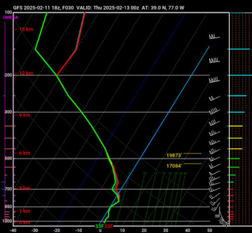
Via www.pivotalweather.com
The temperature at the surface and towards the bottom of this skew-t graph is above freezing, so we probably won’t expect any freezing rain. Unfortunately for us, this makes way for a miserable, cold rain in the evening.
Hopefully, the rainy end of our day won’t get you all down too much. Enjoy the snow when you can and stay cozy towards the end of today. We’re all looking forward to how the rest of the day plays out. Enjoy the snow day, Terps!
– Frances Schoenly
Featured image via Anjali Vidyasagar