
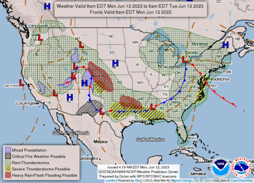
Today:
With wildfire smoke no longer a concern this week, we can now focus on other relevant weather in our region. Scattered showers and thunderstorms are the theme today, with the highest chances of precipitation being from the late-morning through late-afternoon. It’ll be seasonably warm, with temperatures getting into the upper 70s by mid-afternoon, accompanied by some very muggy air as humidity is expected to be high throughout the day. Winds will be out of the south at 10 to 12 mph.
Tonight:
A cold front moves through sometime in the early evening hours, bringing with it the last chance for storms for the night. Clearer skies and cooler air move in behind this front as temperatures drop into the low 60s to upper 50s. Winds shift to the west-northwest after the front moves through and it remains breezy overnight.
Tomorrow (Tuesday):
Clear skies and dry air return, making for a very nice day to be outside. Though the cold front did its job in lowering the humidity, it didn’t make much of a dent in temperatures as the high is expected to be in the low 80s. A steady westerly breeze at 8-10 mph should help in keeping it feel pleasant outside, even in the direct sunlight.
Tomorrow Night:
A slight chance for a light drizzle or two is present overnight, though nothing too major is expected. Cloud coverage increases in anticipation of a new low-pressure system making its way through the Northeastern U.S.. Temperatures drop into the low 60s and winds shift more southerly at 8-10 mph.
Featured image via Pixabay.com