
Today: Happy Friday! The warm temperatures will persist throughout today. We will begin in the low 60s with clear skies. A high pressure to the south will keep the sun shining as well as bringing warm air into our region. By the afternoon, temperatures will be in the low 80s with winds turning from the south at 6 mph by the afternoon. Dewpoints will stay in the mid 60s.
Tonight: Clouds will begin to increase throughout the evening as a cold front approaches. Tonight will remain mild with temperatures dropping only to around 65 degrees. Winds will be south at 7 mph.
Tomorrow (Saturday): Change is here! Temperatures will likely top out around the low 80s before a cold front moves through our region. The cold front will bring with it a 40% chance of rain this afternoon. However, behind the front, fall weather will return with cooler temperatures and drier air. Dew points will drop into the low 40s, so turn off the AC and open the windows, but bring a jacket tonight as lows will drop to the mid 50s.
A look ahead: Once the cold front pushes through our region Saturday afternoon, the rest of the weekend will be cool and dry. The high will only reach the upper 60s on Sunday and the low will be around the upper 40s. Remember to bring a jacket if you plan to go out.
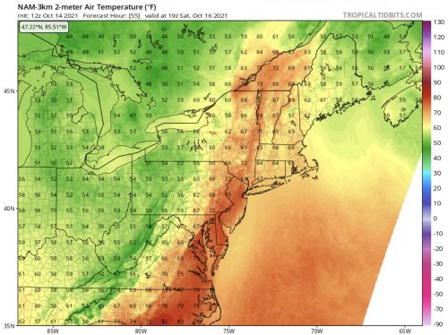
Temperatures in and around Maryland on Saturday at 3 p.m. when a cold front will move through the region. Temperatures ahead of front are in the uppers 70’s. Behind the front, temperatures are in the uppers 50’s. Image via tropicaltidbits.com