March is typically the month that transitions from cold and windy weather to mild and occasionally rainy weather. We will see some of that transition over the next week.
Today: We still have that typical January feel today coming off of cold temps in the 20s, rising only into the mid-40s this afternoon, around ten degrees below average. The good news is that winds should be lighter than yesterday at about 10 mph from the southwest, so there shouldn’t be much wind chill. Skies will be partly cloudy.
Tonight: Very cold again due to light winds and clear skies. Lows will be in the lower 20s.
Tomorrow: Overall it’s very similar to today except with more sun and lighter winds. Highs are again in the mid-40s only, typical for January.
Tomorrow night: See Saturday night’s forecast. It’s the same thing.
Pattern Change Ahead

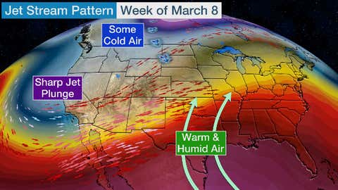
Jet stream pattern for next week, shows the DMV in the warm and mostly dry sector. Image via The Weather Channel.
Next week will turn much milder. Starting Monday, our highs should make it into the lower 50s. But Tuesday brings the real warm-up with temps shooting into the upper 60s! The remainder of the week stays warm as well with a chance to hit 70 by the end of the week. (For reference, we haven’t reached 70 degrees at all since November). Lows should primarily be in the 40s to near 50. Rain chances are also minimal, with plenty of sun all through the week.
