
Today:
Since I’m writing this at 10 am Wednesday night I don’t know what the night will bring us. However, I imagine but the time you all are reading this, the roads will be a mess and snowball flights will be aplenty. The area has released a winter storm warning, so make sure all pets are inside and make every attempt to stay off the roads throughout the day. Expect flurries to come down at the crack of dawn and then change to heavy snow right before 10am. After 10am is when things really get interesting. Throughout the majority of the day expect some mix of freezing rain and wintry mix. This will unfortunately spoil all the sledding hills.
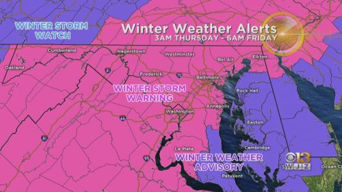
Winter Storm Warning and Watch Map via CBS News
Tonight:
Expect much of the same wintry mix hellscape to continue into Friday night. Again if possible, avoid driving on the roads as much as possible. Temperatures should stay mostly just below freezing with wind speeds staying below 5 mph.
Tomorrow:
Once Friday afternoon rolls around, the winter storm should have finally passed through. The sun should peek through the clouds for most of the day, but they’ll eventually give way to a clear, cold night.
A Look Ahead:
After a crazy week, the weekend should be sunny, yet cold. If there’s any snow or ice left, the intense mid-day rays should melt most of it away. Expect Saturday to be just above freezing and Sunday to head into the high 30s.
Featured image via Pixabay.com