
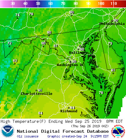
Today:
Cool temperatures in the morning may leave us some fog to send us off into the mid-week. Slowly rising from the mid to high 50s to a balmy 80 degrees and sunny by the late afternoon, it is shaping up to be the perfect day to spend outside. Get out those hammocks and frisbees, because the mall will be prime real estate to enjoy that low humidity. You may want to use some sunscreen if you’re going for a stress-relieving walk, or even go for that bike ride to Lake Artemesia that you’ve been putting off.
Tonight:
It is once again looking like a cool evening dropping down to the mid 60s. You might want to take a light jacket if you are planning on staying out late tonight. Swimming in fountains may sound enticing on a Wednesday night, but just consider those freshman plagues going around and you may want to think twice about taking a dip.
Tomorrow (Thursday):
Thursday will bring in warmer temperatures rising up to the upper 80s by the afternoon, touching 90 degrees by the late afternoon. Some clouds may pop up around this time, but much needed rain is unlikely for the DC area. Relief arrives as temperatures drop into the low 60s by nightfall as a small cold front passes through, sending us off into a busy football weekend for College Park.
A Look Ahead:
Temperatures are looking as optimal as they could ever be for Friday night’s Penn State game. With the highs in the upper 70s, they will fall into the upper 60s by nightfall – bringing along a light jacket could pay off if the game lasts into the late hours. Temperatures will increase into the weekend bringing highs into the upper 80s once again. Without that pesky humidity it will be perfect for outdoor activities in the morning and early afternoon, but look out for possible thunderstorms later in the day.
Featured image via Pixabay